- FORUM
- PROJECTS
- ABOUT US
- RESOURCES
- CONTACT US
- FORUM
- PROJECTS
- ABOUT US
- RESOURCES
- CONTACT US
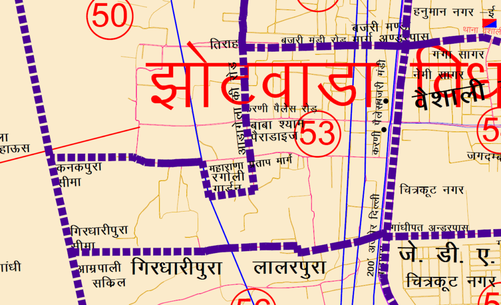
Municipal Corporation Jaipur Greater Ward No. 53 in Jhotwara Legislative Assembly Constituency according to 5th Jan 2020 LOCAL SELF GOVERNMENT DEPARTMENT F.10 (Elec) LSG/20/2 Gazette Notification of Ward Delimitation Nagar Nigam Jaipur Greater
झोटवाडा विधानसभा क्षेत्र में जयपुर नगर निगम (ग्रेटर) वार्ड क्रमांक 53

गांधीपथ 200 फीट दिल्ली-जयपुर हाईवे अण्डरपास से उत्तर दिशा की तरफ करणी पैलेस अण्डरपास तक पश्चिमी भाग, करणी पैलेस अण्डरपास से पश्चिम दिशा की तरफ छोटी एच.टी. लाईन का दक्षिण भाग, छोटी एच.टी. लाइन से उत्तर की ओर चलते हुए बजरी मण्डी रोड तक का पश्चिम भाग, बजरी मण्डी रोड पर पश्चिम की ओर आडा गेला की रोड (नवजीवन स्कूल वाली रोड) तिराहा तक का दक्षिणी भाग आडा गेला तिराहे (नवजीवन स्कूल वाली रोड) से दक्षिण दिशा की तरफ बाबा श्याम पैराडाइज तक करणी पैलेस रोड होते हुये महाराणा प्रताप मार्ग कनकपुरा की सीमा को छोडते हुये रंगोली गार्डन के पूर्वी दक्षिणी कोने तक। रंगोली गार्डन के पूर्वी-दक्षिणी कोने से रंगोली गार्डन को छोड़ते हुए पश्चिम दिशा में चलते हुए चौटाला फार्म हाउस तक का दक्षिण भाग, चौटाला फार्म हाउस से दक्षिण दिशा में चलते हुए गांधीपथ आम्रपाली सर्किल तक का पूर्वी भाग, गांधी पथ आम्रपाली सर्किल से पूर्व में चलते हुए गांधी पथ अण्डर पास, 200 फुट जयपुर-दिल्ली हाईवे तक का उत्तरी भाग।
JMC Greater Ward 53
Population : 12536
Starting from Gandhi Path Underpass on the 200 Feet Delhi-Jaipur Highway, heading towards the north, the western part up to Karni Palace Underpass. From Karni Palace Underpass towards the west, the southern part of Chhoti H.T. Line, from Chhoti H.T. Line towards the north, the western part up to Bajri Mandi Road. On Bajri Mandi Road towards the west, the southern part up to the Ada Gela Ki Road (Navjeevan School Road) intersection. From Ada Gela intersection (Navjeevan School Road) towards the south, heading towards Baba Shyam Paradise on Karni Palace Road, leaving the boundary of Maharana Pratap Marg Kanakpura. Passing through the eastern-southern corner of Rangoli Garden. Leaving Rangoli Garden from the eastern-southern corner, heading towards the west, the southern part up to Chautala Farm House. From Chautala Farm House towards the south, heading towards Gandhi Path Amrapali Circle, the eastern part up to Gandhi Path Underpass. From Gandhi Path Amrapali Circle towards the east, heading towards Gandhi Path Underpass, the northern part up to the 200 Feet Jaipur-Delhi Highway.
Download Map
NNJ Greater : Demarcation of Ward in Nagar Nigam Jaipur Greater Map .pdf
NNJ Heritage : Demarcation of Ward in Nagar Nigam Jaipur Heritage Map.pdf
Home page : Demarcation of Ward in Nagar Nigam Jaipur
1 Comment
[…] Ward No. 46 | Ward No. 47 | Ward No. 48 | Ward No. 49 | Ward No. 50 | Ward No. 51 | Ward No. 52 | Ward No. 53 | Ward No. 54 | Ward No. 55 | Ward No. 56 | Ward No. 57 | Ward No. 58 | Ward No. 59 | Ward No. 60 […]