Municipal Corporation Jaipur Greater Ward No. 119 in Bagru Legislative Assembly Constituency according to 5th Jan 2020 LOCAL SELF GOVERNMENT DEPARTMENT F.10 (Elec) LSG/20/2 Gazette Notification of Ward Delimitation Nagar Nigam Jaipur Greater
बगरू विधानसभा क्षेत्र में जयपुर नगर निगम (ग्रेटर) वार्ड क्रमांक 119
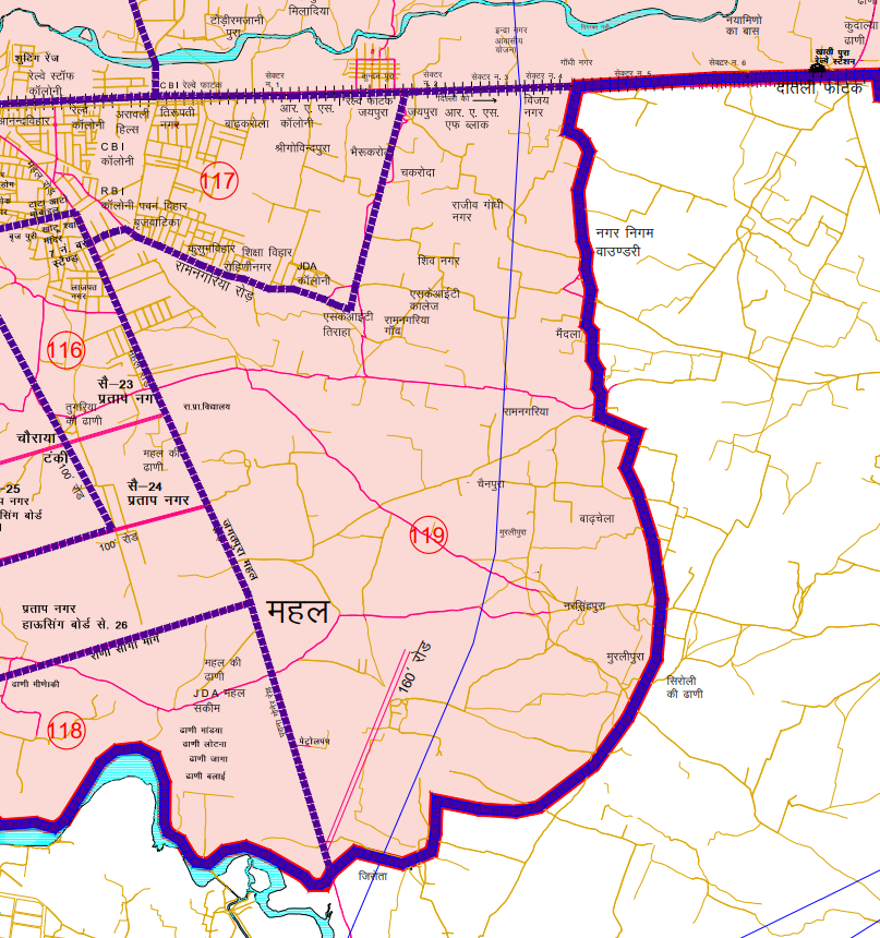
कुन्दनपुरा रेल्वे फाटक से शुरू कर पूर्व दिशा की ओर दिल्ली रेलवे लाईन पर चलकर दाहिनी ओर की कॉलोनियों, जयपुरा, आर.ए.एस कॉलोनी एफ ब्लॉक, विजय नगर, राजीव गाँधी नगर इत्यादि को शामिल करते हुए नगर निगम की सीमा तक। यहाँ से दक्षिण दिशा की ओर नगर निगम की बाउण्ड्री के साथ-साथ चलते हुये व दाहिने हिस्से को शामिल करते हुए मैदला गाँव, चैनपुरा, मुरलीपुरा, बाढ़चेला, नृसिंहपुरा, मुरलीपुरा गाँव की राजस्व सीमा को शामिल करते हुए जगतपुरा महल रोड़ तक। यहाँ से उत्तर की ओर महल रोड़ मुख्य सड़क पर चलकर दाहिने हिस्से को शामिल करते हुए 7 नम्बर बस स्टैण्ड तक। यहां से पूर्व दक्षिण दिशा में रामनगरिया रोड पर दाहिनी ओर की कॉलोनियों को शामिल करते हुये एस.के.आई.टी तिराहे तक। यहाँ से उत्तर दिशा की ओर चलकर दायें हिस्से को शामिल करते हुए रामनगरिया गांव, शिव नगर, एस.के.आई.टी कॉलेज इत्यादि को शामिल करते हुये कुन्दनपुरा रेल्वे फाटक तक समस्त भाग।
JMC Greater Ward 119
Population : 9338
Area: 1210 Hectare
Starting from Kundanpura Railway Crossing, moving towards the east direction along the Delhi railway line, including colonies on the right side such as Jaypura, R.A.S Colony F Block, Vijay Nagar, Rajiv Gandhi Nagar, etc., up to the boundary of the municipal corporation. From here, moving towards the south direction along with the boundary of the municipal corporation, including the village of Maidala, Chainpura, Murlipura, Badhchela, Nrisinghpura, up to the revenue boundary of Murli Pura village, encompassing Jagatpura Mahal Road. From here, moving towards the north direction on Mahal Road main road, including the right side, up to the 7 Number Bus Stand. From here, including colonies on the right side on Ramnagariya Road towards the southeast direction, up to S.K.I.T Tiraha. Moving towards the north direction from here, including the right side, encompassing Ramnagariya village, Shiv Nagar, S.K.I.T College, etc., up to Kundanpura Railway Crossing, encompassing the entire stretch.
Google location Map
Download Map
Register as FD Architects and Planners forum member and login to download map pdf use only for Educational Purposes.
NNJ Greater : Demarcation of Ward in Nagar Nigam Jaipur Greater Map .pdf
NNJ Heritage : Demarcation of Ward in Nagar Nigam Jaipur Heritage Map.pdf
Home page : Demarcation of Ward in Nagar Nigam Jaipur
JDA Jaipur Zone
Zone 1 | Zone 2 | Zone 3 | Zone 4 | Zone 5 | Zone 6 | Zone 7 | Zone 8 | Zone 9 | Zone 10 | Zone 11 | Zone 12 | Zone 13 | Zone 14 | PRN-N1 | PRN-N2 | PRN-S1 | PRN-S2
Register as FD Architects and Planners forum member and login to download map pdf use only for Educational Purposes.
FD Architect & Planning Community Forum Discussion
Division of Nagar Nigam Jaipur in two parts
Disclaimer
The translation may not be an exact word-to-word translation of Gazette Notification but is an attempt to convey the meaning accurately. Information on this site is purely for education purpose. The materials used and displayed on the Sites, including text, photographs, graphics, illustrations and artwork, video, music and sound, and names, logos, IS Codes, are copyrighted items of respective owner. Front Desk is not responsible and liable for information shared above
1 Comment
[…] 112 | Ward No. 113 | Ward No. 114 | Ward No. 115 | Ward No. 116 | Ward No. 117 | Ward No. 118 | Ward No. 119 | Ward No. 120 | Ward No. 121 | Ward No. 122 | Ward No. 123 | Ward No. […]