Municipal Corporation Jaipur Greater Ward No. 97 in Sanganer Legislative Assembly Constituency according to 5th Jan 2020 LOCAL SELF GOVERNMENT DEPARTMENT F.10 (Elec) LSG/20/2 Gazette Notification of Ward Delimitation Nagar Nigam Jaipur Greater
सांगानेर विधानसभा क्षेत्र में जयपुर नगर निगम (ग्रेटर) वार्ड क्रमांक 97
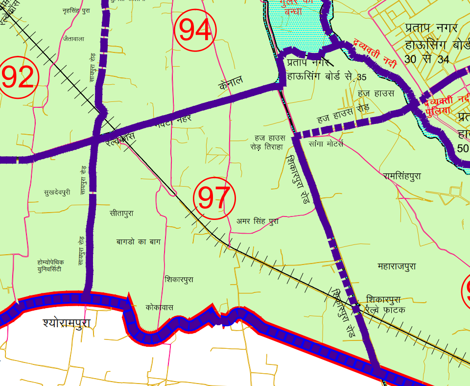
हज हाउस रोड़ द्रव्यवती नदी सैक्टर 35 कार्नर से उत्तर पश्चिम दिशा में द्रव्यवती नदी के सहारे-सहारे गुलर के बन्धे तक एवं गुलर के बन्धे से दक्षिण-पश्चिम दिशा की और चलते हुये शिकारपुरा रोड तक। यहां से नेवटा नहर के सहारे-सहारे पश्चिम की और चलते हुये बाये हिस्से को सम्मिलित करते हुये रेल्वे लाईन पार करते हुये सायपुरा रोड नेवटी नहर क्रास तक। यहां से सायपुरा रोड पर दक्षिण की और चलते हुये बागडों का बाग, होते हुये होम्योपेथिक यूनिवसिर्टी को छोडते हुए पूर्व की ओर कोकावास की सम्पूर्ण आबादी को सम्मलित करते हुये शिकारपुरा गांव, जोतडवाला गांव कि राजस्व सीमा को सम्मिलित करते हुये नगर निगम की सीमा के सहारे- सहारे शिकारपुरारोड तक। यहां से उत्तर कि और चलते हुये गोविन्दपुरा गांव को छोडते हुये रेल्वे लाईन क्रॉस करते हुये शिकारपुरा रोड पर चलते हुये बाये भाग को शामिल करते हुये हजहाऊस रोड तिराहा तक। यहां से पूर्व की और हजहाऊस को सम्मिलित करते हुए एवं हजहाऊस रोड पर चलते हुये दाये भाग को छोडते हुये द्रव्यवती नदी सैक्टर 35 के कार्नर तक का समस्त भाग।
JMC Greater Ward 97
Population : 12269
Area: 220 Hectare
Starting from Haj House Road, moving in the northwest direction along the Dravyavati River to the bunds of Gular, and from the bunds of Gular, moving in the southeast direction towards Shikarpura Road. From here, following the western side along the Neva Canal, crossing the railway line, and integrating with the left side, crossing Saypura Road to Neva Canal Cross. From here, moving south on Saypura Road, passing through Bagdons Ka Bagh, Homoeopathic University, and leaving towards the east, covering the entire population of Kokavas, Shikarpura Village, Jotdawala Village, integrating with the revenue boundary, and reaching the Nagar Nigam boundary along Shikarpura Road. From here, moving north and leaving Govindpura Village, crossing the railway line, moving along Shikarpura Road, integrating with the left side, reaching Haj House Road Tiraha. From here, moving east and integrating with Haj House, and moving along Haj House Road, leaving the right part, reaching the corner of Sector 35 along the Dravyavati River. This covers the entire area up to the corner of Sector 35 along the Dravyavati River.
Download Map
Register as FD Architects and Planners forum member and login to download map pdf use only for Educational Purposes.
NNJ Greater : Demarcation of Ward in Nagar Nigam Jaipur Greater Map .pdf
NNJ Heritage : Demarcation of Ward in Nagar Nigam Jaipur Heritage Map.pdf
Home page : Demarcation of Ward in Nagar Nigam Jaipur
Register as FD Architects and Planners forum member and login to download map pdf use only for Educational Purposes.
JDA Jaipur Zone
Zone 1 | Zone 2 | Zone 3 | Zone 4 | Zone 5 | Zone 6 | Zone 7 | Zone 8 | Zone 9 | Zone 10 | Zone 11 | Zone 12 | Zone 13 | Zone 14 | PRN-N1 | PRN-N2 | PRN-S1 | PRN-S2
FD Architect & Planning Community Forum Discussion
Division of Nagar Nigam Jaipur in two parts
Disclaimer
The translation may not be an exact word-to-word translation of Gazette Notification but is an attempt to convey the meaning accurately. Information on this site is purely for education purpose. The materials used and displayed on the Sites, including text, photographs, graphics, illustrations and artwork, video, music and sound, and names, logos, IS Codes, are copyrighted items of respective owner. Front Desk is not responsible and liable for information shared above
1 Comment
[…] | Ward No. 90 | Ward No. 91 | Ward No. 92 | Ward No. 93 | Ward No. 94 | Ward No. 95 | Ward No. 96 | Ward No. 97 | Ward No. 98 | Ward No. 99 | Ward No. 100 | Ward No. 101 | Ward No. 102 | Ward No. […]