Municipal Corporation Jaipur Greater Ward No. 114 in Bagru Legislative Assembly Constituency according to 5th Jan 2020 LOCAL SELF GOVERNMENT DEPARTMENT F.10 (Elec) LSG/20/2 Gazette Notification of Ward Delimitation Nagar Nigam Jaipur Greater
बगरू विधानसभा क्षेत्र में जयपुर नगर निगम (ग्रेटर) वार्ड क्रमांक 114
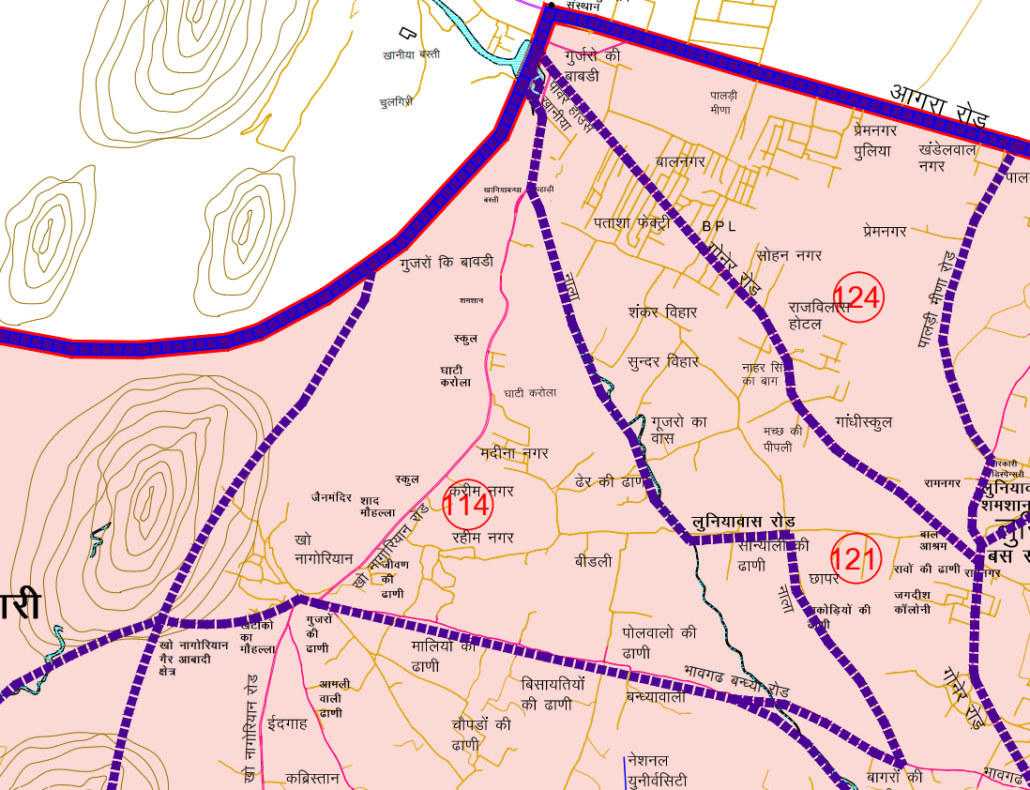
खानियाँ पावर हाउस के दक्षिण पश्चिम कार्नर से खो- नागोरियन रोड़ पर दक्षिण दिशा की ओर चलकर दायें हिस्से को शामिल करते हुए नाले के सहारे-सहारे चलकर दायीं क्षेत्र घाटी करोलान, ढेर की ढाणी को लेते हुऐ लुणियावास जाने वाली रोड तक। यहां से पूर्व की ओर सडक पर चलते हुए दायें हिस्से को लेते हुये सान्याली की ढाणी तक। यहां से दक्षिण पूर्व दिशा में चलकर दायें तरफ के भाग को लेते हुये भावगढ बंधा वाले रोड तक। यहां से पश्चिम उत्तर दिशा मे चलकर दायें तरफ के हिस्से को लेते हुये बडे नाले तक। यहाँ से पश्चिम दिशा की ओर दाहिनी हिस्से को शामिल करते हुए भावगढ़ बंधा रोड़ पर पोल वालों की ढ़ाणी बीडली, रहीम नगर, करीम नगर, मदीना नगर, जीवण की ढ़ाणी को शामिल करते हुए खो-नागोरियन बाईपास रोड तक। यहाँ से पश्चिम की ओर चलकर खो-नागोरियन गाँव व आबादी को शामिल करते हुए वन विभाग की काल्पनिक सीमा तक। यहाँ से काल्पनिक रेखा के सहारे-सहारे उत्तर-पूर्व दिशा की ओर दाहिने हिस्से को शामिल करते हुए बगरू विधानसभा की सीमा तक। यहाँ से उत्तर दिशा की ओर विधानसभा की बाउण्ड्री के सहारे-सहारे खानिया पावर हाउस के दक्षिण पश्चिम कार्नर तक का समस्त क्षेत्र।
JMC Greater Ward 114
Population : 11464
Area: 542 Hectare
Starting from the southwest corner of Khaniya Power House, moving towards the south on the Kho-Nagorian Road, taking the right side and following along the drain, passing through the right side of Ghati Karolan, Dher Ki Dhani, reaching the road leading to Luniyawas. From here, moving towards the east on the road, taking the right side, reaching Sanyali Ki Dhani. From here, heading southeast, taking the right side, reaching Bhawgadh Bandha Road. Moving towards the west-north direction from here, taking the right side, reaching Bade Nale. From here, moving towards the west direction, taking the right side, incorporating the right side, reaching Pol Walo Ki Dhani on Bhawgadh Bandha Road, including areas such as Beedli, Rahim Nagar, Kareem Nagar, Madina Nagar, Jeevan Ki Dhani, up to Kho-Nagorian Bypass Road. From here, heading towards the west, including the right side, incorporating Kho-Nagorian Village and Population, reaching the imaginary boundary of the Forest Department. From here, following the imaginary line, including the right side, heading towards the northeast direction, incorporating the right side, reaching the boundary of Bagru Vidhansabha. From here, heading north, including the right side, following the boundary of the Vidhan Sabha, reaching the southwest corner of Khaniya Power House, covering the entire area.
Download Map
Register as FD Architects and Planners forum member and login to download map pdf use only for Educational Purposes.
NNJ Greater : Demarcation of Ward in Nagar Nigam Jaipur Greater Map .pdf
NNJ Heritage : Demarcation of Ward in Nagar Nigam Jaipur Heritage Map.pdf
Home page : Demarcation of Ward in Nagar Nigam Jaipur
JDA Jaipur Zone
Zone 1 | Zone 2 | Zone 3 | Zone 4 | Zone 5 | Zone 6 | Zone 7 | Zone 8 | Zone 9 | Zone 10 | Zone 11 | Zone 12 | Zone 13 | Zone 14 | PRN-N1 | PRN-N2 | PRN-S1 | PRN-S2
Register as FD Architects and Planners forum member and login to download map pdf use only for Educational Purposes.
FD Architect & Planning Community Forum Discussion
Division of Nagar Nigam Jaipur in two parts
Disclaimer
The translation may not be an exact word-to-word translation of Gazette Notification but is an attempt to convey the meaning accurately. Information on this site is purely for education purpose. The materials used and displayed on the Sites, including text, photographs, graphics, illustrations and artwork, video, music and sound, and names, logos, IS Codes, are copyrighted items of respective owner. Front Desk is not responsible and liable for information shared above
1 Comment
[…] 107 | Ward No. 108 | Ward No. 109 | Ward No. 110 | Ward No. 111 | Ward No. 112 | Ward No. 113 | Ward No. 114 | Ward No. 115 | Ward No. 116 | Ward No. 117 | Ward No. 118 | Ward No. 119 | Ward No. 120 | Ward […]