Municipal Corporation Jaipur Greater Ward No. 115 in Bagru Legislative Assembly Constituency according to 5th Jan 2020 LOCAL SELF GOVERNMENT DEPARTMENT F.10 (Elec) LSG/20/2 Gazette Notification of Ward Delimitation Nagar Nigam Jaipur Greater
बगरू विधानसभा क्षेत्र में जयपुर नगर निगम (ग्रेटर) वार्ड क्रमांक 115
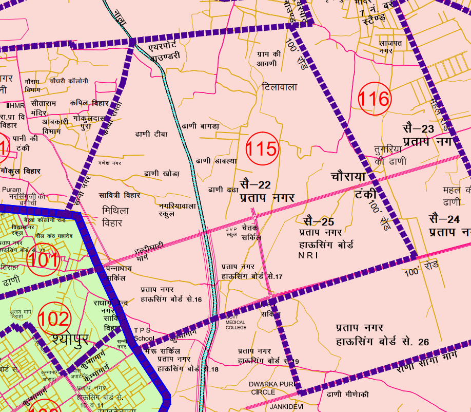
एन.आर.आई सर्किल से प्रारम्भ कर पूर्व दिशा की ओर 100 फीट रोड़ पर चलकर बायें हिस्से को लेते हुये एन.आर.आई कालोनी के दक्षिण पूर्वी कोने तक। यहाँ से उत्तर दिशा की ओर 100 फीट रोड पर चलकर बायीं तरफ की ओर की कालोनी को लेते हुये हल्दीघाटी मार्ग चौराहे होते हुए उत्तर दिशा की तरफ चलते हुये बायीं ओर की कालोनी सैक्टर-22, प्रताप नगर, टिलावाला को शामिल करते हुये एयरपोर्ट बाउण्ड्री तक। एयरपोर्ट की बाउण्ड्री के सहारे-सहारे पश्चिम दिशा की ओर बायें क्षेत्र को शामिल करते हुये एयरपोर्ट के नीचे से आ रहे बड़े नाले तक। यहां से दक्षिण-पश्चिम दिशा में कच्चे रास्ते पर चलते हुए बायें तरफ की कालोनियां ढाणी टीबा, ढाणी खोडा, ढाणी बागडा, नगरियावाला, मिथिला विहार, को शामिल करते हुये विधानसभा की बाउण्ड्री तक। यहाँ से दक्षिणी पूर्वी दिशा में चलते हुए बाये हिस्से को शामिल करते हुए पन्नाधाय सर्किल हल्दीघाटी मार्ग तक। यहाँ से दक्षिण की ओर बायीं तरफ का क्षेत्र सैक्टर- 16 प्रताप नगर को लेते हुये कुम्भा मार्ग भैरू जी सर्किल तक। यहाँ से पूर्व दिशा की ओर चलकर बायें हिस्से को लेते हुये सैक्टर 17 प्रताप नगर को शामिल कर एन.आर.आई सर्किल तक का समस्त भाग।
JMC Greater Ward 115
Population : 9789
Area: 417 Hectare
Starting from the N.R.I Circle, moving towards the east on the 100 feet road, taking the left side, reaching the southeast corner of the N.R.I Colony. From here, heading towards the north on the 100 feet road, taking the left side, reaching the colony on the left side, and then moving towards the north direction from Haldighati Marg Chowk, taking the left side, incorporating colonies on the left side such as Sector-22, Pratap Nagar, and Tilawala, up to the Airport Boundary. Along the Airport Boundary, moving towards the west direction, taking the left side, incorporating the left area, and then reaching the large drain coming from under the airport. From here, heading towards the south-southwest direction on the dirt road, taking the left side, incorporating colonies on the left side such as Dhani Tiba, Dhani Khoda, Dhani Bagda, Nagariyawala, Mithila Vihar, up to the boundary of the Vidhan Sabha. From here, moving towards the southeast direction, taking the left side, incorporating the left area, reaching Pannadhay Circle on Haldighati Marg. From here, heading towards the south, taking the left side, incorporating the area towards Sector-16 Pratap Nagar, reaching Bhairu Ji Circle. From here, moving towards the east, taking the left side, incorporating the left area, reaching Sector 17 Pratap Nagar, and finally reaching the N.R.I Circle.
Download Map
Register as FD Architects and Planners forum member and login to download map pdf use only for Educational Purposes.
NNJ Greater : Demarcation of Ward in Nagar Nigam Jaipur Greater Map .pdf
NNJ Heritage : Demarcation of Ward in Nagar Nigam Jaipur Heritage Map.pdf
Home page : Demarcation of Ward in Nagar Nigam Jaipur
JDA Jaipur Zone
Zone 1 | Zone 2 | Zone 3 | Zone 4 | Zone 5 | Zone 6 | Zone 7 | Zone 8 | Zone 9 | Zone 10 | Zone 11 | Zone 12 | Zone 13 | Zone 14 | PRN-N1 | PRN-N2 | PRN-S1 | PRN-S2
Register as FD Architects and Planners forum member and login to download map pdf use only for Educational Purposes.
FD Architect & Planning Community Forum Discussion
Division of Nagar Nigam Jaipur in two parts
Disclaimer
The translation may not be an exact word-to-word translation of Gazette Notification but is an attempt to convey the meaning accurately. Information on this site is purely for education purpose. The materials used and displayed on the Sites, including text, photographs, graphics, illustrations and artwork, video, music and sound, and names, logos, IS Codes, are copyrighted items of respective owner. Front Desk is not responsible and liable for information shared above