The integration of land use with transportation systems has to happen at all scale/ levels of planning and through multiple intervention mechanisms. The most important elements of land use transport integration are listed below:
1. Enabling Urban Structure
2. Complete network and complete streets
3. Public Transit and its Strategic Alignment
4. Transit oriented development and value capture 1.Along routes 2.Around Transit interchanges
5. Accessibility improvements in terms of local area plans (last mile connectivity)
6. Re-development & Re-vitalization & Transit 1.Inner city 2.Derelict areas 3.Slums
7. Integrated Multimodal Transit Interchanges
Apart from the above mentioned elements Inter jurisdictional coordination is also important overarching aspect.
Enabling Urban Structure
While there are many elements that constitute the physical form of the city, the below are critical to land use transport integration. These characteristics have a direct impact on travel patterns and are in turn impacted by the characteristics of the city’s transportation system.
Aspect of Enabling Urban Structure
Settlement pattern and Size: It refers to the number of houses within a contagious built-up area. It is important to note that cities need to keep a small settlement size in order to reduce the trip lengths. Hence infill areas and regeneration areas need to be identified and used for future growth before identifying new growth areas.
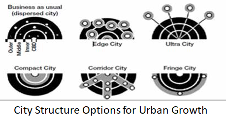
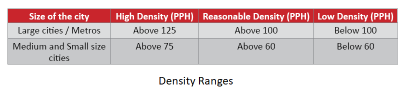
Distribution of population density: Cities will need to adopt density as a tool to keep the settlement size small. Density is viewed in the form of gross densities and the current density should be used as a reference point to plan for future densities. In order to achieve a compact city form a high density scenario is desirable. However the cities should also understand that one cannot just increase the density considerable since most of the city will already be built up and the scope for increasing the density is
hence limited to regeneration and vacant land development. The following density ranges can be used as a guideline to understand the concept of high and low.
Urban Spatial structure refers to the inter relations between urban form and its underlying interaction of people, freight and their movement. Studies have explored the manner in which one can assess the basic concept of structuring urban form. A set of indices developed like Centrality index, Size index, Coverage index and Attractiveness index help in determining the urban structure. These qualitative measurement tools of spatial structure using movement data can be used to help develop insights into urban dynamics and its planning.4
1 Centrality index measures how central an area is in terms of attracting people to do various activities and it is a combination of diversity and density functions.
2 Size index measures how large the centers are geographically
3 Coverage index measure the spatial influence of the centre, defined by the average distance people are willing to travel to the centre.
4 Attractiveness index measures the intensity of the force that attracts people to one centre, and it is based on size and coverage.
Complete Network and Complete Streets
When cities are made more compact in terms of physical form and in terms of functional interrelationships (mix of uses), it is expected that trip lengths will reduce and the modal choice will shift only towards public transport, but also towards pedestrian movement and non-motorized traffic. In that situation, the efficiency of the road network at macro and micro levels becomes very important. So does the usability of the street for all modes of movement (and not just motor vehicles).

Public Transit & Strategic Alignments
In most Indian cities, the provision of public transport is a post facto intervention once new growth areas have developed. Growth happening in areas where public transport has not been planned results in an increase in the number of trips made by private vehicles as well as an increase in trip lengths, eventually leading to greater traffic congestion, trip delays, higher travel costs and pollution.
In this regards it is important to have a strategic spatial plan for the sustainable growth of a city, this plan will sets out the spatial development priorities, both geographically and thematically, and which permits the production of a complementary strategic transport plan for the enhancement of the transport network, in a way that ensures transport capacity with the right accessibility and quality is provided just in time to support the various land-use developments. This alignment will also allow the timely extraction of value from respective developments to help fund the transport improvements.
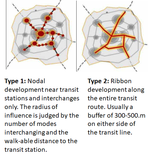
Transit Oriented Development and Value Capture
Transit-oriented development (TOD) is a key element of “smart growth” which emerged in the mid-1980s.
The concept is based on the principle of maximization of access to public transport through mixed use and compact neighbourhoods.
The main elements of this concept include:
• High densities around transit stations
• Mixed land use
• Pedestrian friendly and walk-able neighbourhoods
• Provides multiple transportation choices by multimodal integration
Integrated Multimodal Transit Interchange Facilities
There are three aspects to the multimodal transit integration.
a) Physical integration– This includes integration in terms of network (MRT/BRT/suburban rail/ public transport) hence the networks are planned in such a way that it is convenient to change from one mode to another.
b) Fare integration– Fare integration will ensure that people get onto public transport as this will ensure
that the cost of transportation reasonable. Fare integration can further be of the following types
• Transit Route Integration- Single mode
• Transit modes integration- multimodal
• Transit modes + Intermediate Public Transport System
• Transit modes + Intermediate Public Transport System + Parking
c) Information Integration– Integration can also be achieved if information is easily and freely available to all users. The emphasis needs to be on journey planning where a person is able to make an informed decision on the mode and route one takes.
Institutional Framework for LUTP
Land use and Transport Planning home page
Download Study Notes PDF
Land use and Transport Planning.pdf
Register as member and login to download attachment use this only for Educational Purpose
FD Planning Community Forum Discussion
- Land Use Transport Integration and Density of Urban Growth Toolkit
- Integration of Land Use and Transport Planning
- Introduction – Modelling Transport – Ortuzar Willumsen
- Mathematical Prerequisites from Modelling Transport
- data and space from Modelling Transport
- Trip Generation Modelling from Modelling Transport
- Modal split and direct demand models from Modelling Transport
- Discrete choice models from Modelling Transport
Disclaimer
Information on this site is purely for education purpose. The materials used and displayed on the Sites, including text, photographs, graphics, illustrations and artwork, video, music and sound, and names, logos, IS Codes, are copyrighted items of respective owners. Front Desk is not responsible and liable for information shared above.
1 Comment
[…] Key elements of Integration […]