Planning
JDA APPROVED SCHEME MAP OF SHYAM NAGAR JAIPUR
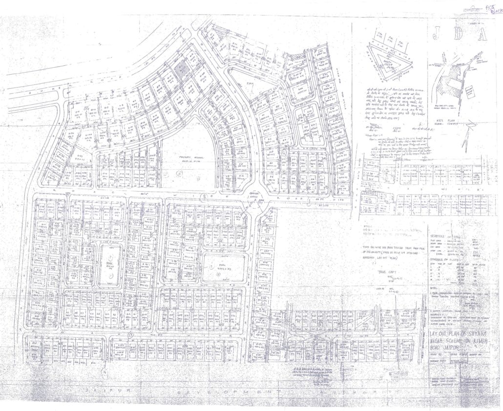
SCHEDULE OF AREA
PLOT AREA = 216461.67 (61.45%)
ROAD AREA = 70428 (20.5%)
FACILITY AREA = 15705.63 (4.45 %)
OPEN AREA = 19327 (5.45%)
OTHER AREA = 30037.54 (8.15%)
TOTAL AREA = 352140.26
SCHEDULE OF PLOTS
| S.NO. | TYPE OF PLOT | SIZE OF PLOT | NO OF PLOTS |
| 1 | S | 70’X110′ | 33 |
| 2 | A | 50’X90′ | 175 |
| 3 | B | 50’X90′ | 109 |
| 4 | C | 35’X70′ | 177 |
| 5 | D | 40’X70′ | 15 |
Designing, Execution and Life span Time period in Planning, Urban Design, Architecture and Interior Design exercise
| Time period | Planning | Urban Design | Architecture | Interior design |
| Designing Phase | 6 Month-2 years | 1 – 6 Month | 15-30 Days | 7-15 Days |
| Execution Phase | 15-20 Year | 3-10 Year | 1-5 Year | 4-6 Month |
| Lifespan | 1000-2000 Year | 150-200 Year | 30-100 Year | 5-20 Year |
Designing, execution, and lifespan periods are crucial phases in the planning, urban design, architecture, and interior design processes. Each phase has specific considerations and timelines which vary depending on the project scale, complexity, and objectives. Here’s an overview of these phases across the mentioned fields:
1. Planning
- Designing Phase:
- Duration: 6 months to 2 years.
- Activities:
- Site analysis
- Stakeholder consultations
- Feasibility studies
- Concept development
- Preliminary designs and master plans
- Regulatory reviews and approvals
- Execution Phase:
- Duration: 15 to 20 years.
- Activities:
- Detailed planning
- Phased implementation
- Coordination with various agencies
- Continuous monitoring and adjustments
- Lifespan:
- Typically 1000 to 2000 years, depending on infrastructure durability and urban growth dynamics.
2. Urban Design
- Designing Phase:
- Duration: 1 to 6 Month.
- Activities:
- Visioning and goal setting
- Urban analysis
- Public consultations
- Drafting urban design frameworks and guidelines
- Integration with transportation, land use, and environmental planning
- Execution Phase:
- Duration: 3 to 10 years or more (phased implementation).
- Activities:
- Infrastructure development
- Public space creation
- Zoning regulation enforcement
- Continuous stakeholder engagement
- Lifespan:
- Can range from 150 to 200 years, influenced by city evolution, technological advancements, and policy changes.
3. Architecture
- Designing Phase:
- Duration: 15-30 Days
- Activities:
- Client brief and requirements analysis
- Conceptual design
- Schematic design
- Design development
- Construction documents preparation
- Execution Phase:
- Duration: 1 to 5 years.
- Activities:
- Site preparation
- Construction management
- Quality control
- Adherence to building codes and standards
- Final inspections and handover
- Lifespan:
- Typically 30 to 100 years, depending on construction quality, materials used, and maintenance practices.
4. Interior Design
- Designing Phase:
- Duration: 7 to15 Days
- Activities:
- Space planning
- Concept and theme development
- Material and finish selections
- Furniture and fixture specifications
- Lighting and color schemes
- Execution Phase:
- Duration: 4 to 6 months.
- Activities:
- Site preparation
- Installation of finishes and fixtures
- Furniture installation
- Final styling and decoration
- Lifespan:
- Typically 5 to 20 years, as interior designs are more frequently updated to keep up with trends and functional needs.
Key Considerations
- Sustainability: Incorporating sustainable practices can extend the lifespan and reduce environmental impact.
- Technology: Advancements can influence both design and execution phases, introducing new tools and materials.
- Regulations: Compliance with local codes and regulations is essential in all phases.
- Maintenance: Regular maintenance is crucial to maximize lifespan and ensure the longevity of the design and construction.
Understanding the timelines and activities involved in each phase helps in better planning and execution of projects, ensuring they meet their intended purpose and stand the test of time.
Municipal Corporation Jaipur Greater Ward No. 133 in Malviya Nagar Legislative Assembly Constituency according to 5th Jan 2020 LOCAL SELF GOVERNMENT DEPARTMENT F.10 (Elec) LSG/20/2 Gazette Notification of Ward Delimitation Nagar Nigam Jaipur Greater
मालवीय नगर विधानसभा क्षेत्र में जयपुर नगर निगम (ग्रेटर) वार्ड क्रमांक 133
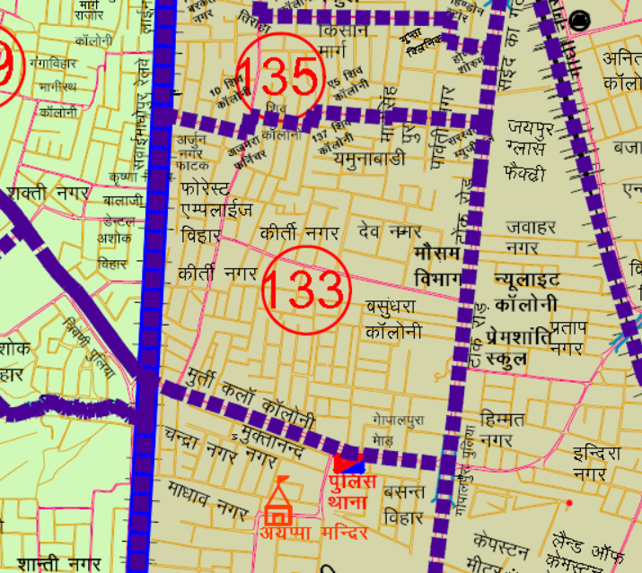
गोपालपुरा चौराहा (पुलिया) से चलकर पश्चिम दिशा में मुख्य गोपालपुरा रोड पर चलकर त्रिवेणी पुलिया तक का दाहिनी का भाग क्षेत्र तथा यहां से उत्तर दिशा रेल्वे ट्रेक के सहारे-सहारे चलकर अर्जुन नगर फाटक तक तथा यहां से पूर्व दिशा में चलकर अजमेरा फर्निशिंग हाउस तक तथा यहां से उत्तर दिशा में प्लॉट नं. 10 शिव कॉलोनी किरण विला तक तथा यहां से पूर्व दिशा में चलकर प्लांट नं. 137 शिव कॉलानी तक तथा यहां से उत्तर दिशा में चलकर ए 5 शिव कॉलोनी तक तथा यहां से पूर्व दिशा में चलकर मुख्य टोंक रोड पर सरस्वती म्युजिकल दुकान तक तथा यहा से दक्षिण दिशा में मुख्य टोंक रोड पर चलकर गोपालपुरा चौराहा (पुलिया) तक का दाहिनी भाग का सम्पूर्ण क्षेत्र।
JMC Greater Ward 133
Population : 11994
Area: 79.8 Hectare
Starting from Gopalpura Chowk (Pulia), moving towards the west direction on the main Gopalpura Road up to Triveni Pulia, encompassing the right part of the area. From here, proceeding towards the north direction along the railway track up to Arjun Nagar Crossing. Then, moving towards the east direction up to Ajmera Furnishing House. Further, heading towards the north direction up to Plot No. 10, Shiv Colony Kiran Villa. Then, moving towards the east direction up to Plant No. 137, Shiv Colony. Proceeding towards the north direction up to A-5, Shiv Colony. Continuing towards the east direction up to Saraswati Musical Shop on the main Tonk Road. Finally, moving towards the south direction on the main Tonk Road up to Gopalpura Chowk (Pulia), forming the complete area of the right part from here to Gopalpura Chowk (Pulia).
Google location Map
Home page : Demarcation of Ward in Nagar Nigam Jaipur
Download Map
Register as FD Architects and Planners forum member and login to download map pdf use only for Educational Purposes.
NNJ Greater : Demarcation of Ward in Nagar Nigam Jaipur Greater Map .pdf
NNJ Heritage : Demarcation of Ward in Nagar Nigam Jaipur Heritage Map.pdf
JDA Jaipur Zone
Zone 1 | Zone 2 | Zone 3 | Zone 4 | Zone 5 | Zone 6 | Zone 7 | Zone 8 | Zone 9 | Zone 10 | Zone 11 | Zone 12 | Zone 13 | Zone 14 | PRN-N1 | PRN-N2 | PRN-S1 | PRN-S2
Register as FD Architects and Planners forum member and login to download map pdf use only for Educational Purposes.
FD Architect & Planning Community Forum Discussion
Division of Nagar Nigam Jaipur in two parts
Disclaimer
The translation may not be an exact word-to-word translation of Gazette Notification but is an attempt to convey the meaning accurately. Information on this site is purely for education purpose. The materials used and displayed on the Sites, including text, photographs, graphics, illustrations and artwork, video, music and sound, and names, logos, IS Codes, are copyrighted items of respective owner. Front Desk is not responsible and liable for information shared above
Municipal Corporation Jaipur Greater Ward No. 132 in Malviya Nagar Legislative Assembly Constituency according to 5th Jan 2020 LOCAL SELF GOVERNMENT DEPARTMENT F.10 (Elec) LSG/20/2 Gazette Notification of Ward Delimitation Nagar Nigam Jaipur Greater
मालवीय नगर विधानसभा क्षेत्र में जयपुर नगर निगम (ग्रेटर) वार्ड क्रमांक 132
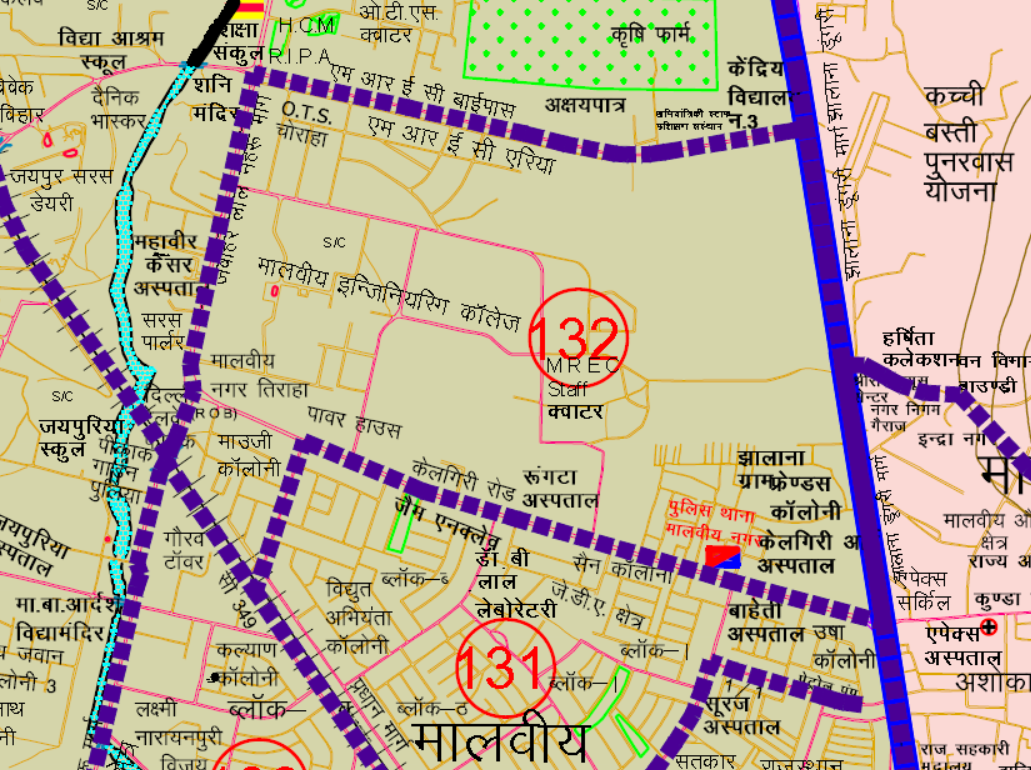
अपैक्स सर्किल से पश्चिम दिशा में कैलगीरी रोड पर चलते हुए प्रधान मार्ग तिराहे पर पॉवर हाउस तक तथा यहां से दक्षिण दिशा में मोजी कॉलोनी को लेते हुए सी-349 रेलवे लाईन तक यहाँ से रेलवे लाईन पिकोक गार्डन पूलिया तक यहाँ जे.एल.एन पर उत्तर की तरफ चलते हुए दाहिना भाग को लेते हुए ओ.टी. एस चौराहा तक यहाँ से पूर्व की तरफ एम.एन.आई.टी कैम्पस के सहारे सहारे झालाना रोड के.वी.-3 तक यहाँ से दक्षिण की तरफ चलते हुए झालाना ग्राम फ्रेन्ड्स कॉलोनी व सम्पूण दाहिना भाग को लेते हुए अपैक्स सर्किल तक का दाहिनी भाग का सम्पूर्ण क्षेत्र।
JMC Greater Ward 132
Population : 12521
Area: 176 Hectare
Starting from Apex Circle, moving towards the west direction on Kalgiri Road, reaching the main road intersection at the Power House, and from there, heading towards the south direction to include Moji Colony up to the C-349 railway line. From here, proceeding on the railway line up to Picnic Garden Pulia. Moving northward on JLN towards the right side, taking the right part up to OTS Chowk. Heading eastwards towards MNIT Campus, along the side of Jhalana Road to V-3. Proceeding towards the south, encompassing Jhalana Gram and Friends Colony, and taking the entire right portion up to Apex Circle, forming the complete area of the right part from here to Apex Circle.
Google location Map
Home page : Demarcation of Ward in Nagar Nigam Jaipur
Download Map
Register as FD Architects and Planners forum member and login to download map pdf use only for Educational Purposes.
NNJ Greater : Demarcation of Ward in Nagar Nigam Jaipur Greater Map .pdf
NNJ Heritage : Demarcation of Ward in Nagar Nigam Jaipur Heritage Map.pdf
JDA Jaipur Zone
Zone 1 | Zone 2 | Zone 3 | Zone 4 | Zone 5 | Zone 6 | Zone 7 | Zone 8 | Zone 9 | Zone 10 | Zone 11 | Zone 12 | Zone 13 | Zone 14 | PRN-N1 | PRN-N2 | PRN-S1 | PRN-S2
Register as FD Architects and Planners forum member and login to download map pdf use only for Educational Purposes.
FD Architect & Planning Community Forum Discussion
Division of Nagar Nigam Jaipur in two parts
Disclaimer
The translation may not be an exact word-to-word translation of Gazette Notification but is an attempt to convey the meaning accurately. Information on this site is purely for education purpose. The materials used and displayed on the Sites, including text, photographs, graphics, illustrations and artwork, video, music and sound, and names, logos, IS Codes, are copyrighted items of respective owner. Front Desk is not responsible and liable for information shared above
Municipal Corporation Jaipur Greater Ward No. 131 in Malviya Nagar Legislative Assembly Constituency according to 5th Jan 2020 LOCAL SELF GOVERNMENT DEPARTMENT F.10 (Elec) LSG/20/2 Gazette Notification of Ward Delimitation Nagar Nigam Jaipur Greater
मालवीय नगर विधानसभा क्षेत्र में जयपुर नगर निगम (ग्रेटर) वार्ड क्रमांक 131

मालवीय नगर ई एच सी सी हॉस्पिटल के सामने 200 फीट बाईपास पर 6/21 से उत्तर दिशा की तरफ चलते हुए गिरधर मार्ग पर अमित भारद्वाज पेट्रोल पम्प तक यहाँ से पूर्व दिशा कि तरफ गिरधर मार्ग पर चलतें हुए सरकारी स्कूल के कोने तक तथा यहां से पूर्व उत्तर दिशा में चलते हुए 11/501 रेल्वे लाईन तक यहां से उत्तर दिशा में चलकर 3/574 तक यहाँ से प्रधान मार्ग दक्षिण-पूर्व की तरफ चलतें हुए गाँधी ग्रह सेक्टर-3 व दूर्गा विहार को लेते हुए प्रधान मार्ग 200 फीट बाईपास रोड तिराहे तक यहाँ से पश्चिम दिशा की तरफ बाईपास रोड पर 6/21 मालवीय नगर तक का सम्पूर्ण दाहिनी भाग का क्षेत्र।
JMC Greater Ward 131
Population : 13107
Area: 83.2 Hectare
Starting from the Malviya Nagar EHC Hospital, proceeding towards the north direction on the bypass road from 6/21, reaching up to Amit Bharadwaj Petrol Pump on Girdhar Marg. From here, moving towards the east direction on Girdhar Marg up to the corner of the Government School, and then heading towards the northeast direction from here to reach the 11/501 railway line. Continuing towards the north direction from here up to 3/574. Moving along the main road towards the southeast direction, passing through Gandhi Grah Sector-3 and Durga Vihar, up to the main road 200 feet bypass road intersection. From here, encompassing the entire right side area up to Malviya Nagar on the bypass road 6/21 towards the west direction.
Google location Map
Home page : Demarcation of Ward in Nagar Nigam Jaipur
Download Map
Register as FD Architects and Planners forum member and login to download map pdf use only for Educational Purposes.
NNJ Greater : Demarcation of Ward in Nagar Nigam Jaipur Greater Map .pdf
NNJ Heritage : Demarcation of Ward in Nagar Nigam Jaipur Heritage Map.pdf
JDA Jaipur Zone
Zone 1 | Zone 2 | Zone 3 | Zone 4 | Zone 5 | Zone 6 | Zone 7 | Zone 8 | Zone 9 | Zone 10 | Zone 11 | Zone 12 | Zone 13 | Zone 14 | PRN-N1 | PRN-N2 | PRN-S1 | PRN-S2
Register as FD Architects and Planners forum member and login to download map pdf use only for Educational Purposes.
FD Architect & Planning Community Forum Discussion
Division of Nagar Nigam Jaipur in two parts
Disclaimer
The translation may not be an exact word-to-word translation of Gazette Notification but is an attempt to convey the meaning accurately. Information on this site is purely for education purpose. The materials used and displayed on the Sites, including text, photographs, graphics, illustrations and artwork, video, music and sound, and names, logos, IS Codes, are copyrighted items of respective owner. Front Desk is not responsible and liable for information shared above
Municipal Corporation Jaipur Greater Ward No. 124 in Bagru Legislative Assembly Constituency according to 5th Jan 2020 LOCAL SELF GOVERNMENT DEPARTMENT F.10 (Elec) LSG/20/2 Gazette Notification of Ward Delimitation Nagar Nigam Jaipur Greater
बगरू विधानसभा क्षेत्र में जयपुर नगर निगम (ग्रेटर) वार्ड क्रमांक 124

लूनियावास बस स्टैण्ड से उत्तर–पश्चिम दिशा में गोनेर रोड पर चलते हुये दायें तरफ की कॉलोनियों को शामिल करते हुए राजविलास होटल, सरकारी स्कुल, सोहन नगर, बी.पी.एल गोदाम, बाल नगर, गुर्जरो की बावडी को शामिल करते हुए गोनेर रोड के दाहिने हिस्से को शामिल करते हुए बगरू विधानसभा की सीमा तक। बगरू विधानसभा की सीमा के सहारे सहारे उत्तर की ओर चलते हुए आगरा रोड़ तक। यहाँ से आगरा रोड पर चलकर दायें हिस्से को लेते हुये प्रेम नगर, खण्डेलवाल नगर को शामिल कर पालडी मीणा रोड तक। यहाँ से दक्षिण दिशा की ओर चलते हुये दायें हिस्से को शामिल कर एवं पालडी मीणा गांव को छोडते हुये लूणियावास श्मशान तक, यहां से दक्षिण दिशा की तरफ लूणियावास बस स्टैण्ड तक का समस्त भाग।
JMC Greater Ward 124
Population : 12557
Area: 266 Hectare
Starting from Luniyavas Bus Stand, moving towards the northwest direction on Goner Road, including colonies on the right side such as Rajvilas Hotel, Government School, Sohan Nagar, B.P.L. Warehouse, Bal Nagar, Gurjaro Ki Bavdi, up to the boundary of Bagru Vidhansabha. Along the boundary of Bagru Vidhansabha towards the north direction, heading towards Agra Road. From here, proceeding on Agra Road, including the area on the right side, up to Prem Nagar, Khandelwal Nagar, and reaching Paladi Meena Road. Moving towards the south direction, including the area on the right side, and leaving Paladi Meena Village, up to Luniyavas cremation ground. From here, towards the south direction, encompassing the entire stretch up to Luniyavas Bus Stand.
Google location Map
21 Wards in Bagru Legislative Assembly Constituency
बगरु विधानसभा क्षेत्र में 21 वार्ड
Ward No. 104 | Ward No. 105 | Ward No. 106 | Ward No. 107 | Ward No. 108 | Ward No. 109 | Ward No. 110 | Ward No. 111 | Ward No. 112 | Ward No. 113 | Ward No. 114 | Ward No. 115 | Ward No. 116 | Ward No. 117 | Ward No. 118 | Ward No. 119 | Ward No. 120 | Ward No. 121 | Ward No. 122 | Ward No. 123 | Ward No. 124
Download Map
Register as FD Architects and Planners forum member and login to download map pdf use only for Educational Purposes.
NNJ Greater : Demarcation of Ward in Nagar Nigam Jaipur Greater Map .pdf
NNJ Heritage : Demarcation of Ward in Nagar Nigam Jaipur Heritage Map.pdf
Home page : Demarcation of Ward in Nagar Nigam Jaipur
JDA Jaipur Zone
Zone 1 | Zone 2 | Zone 3 | Zone 4 | Zone 5 | Zone 6 | Zone 7 | Zone 8 | Zone 9 | Zone 10 | Zone 11 | Zone 12 | Zone 13 | Zone 14 | PRN-N1 | PRN-N2 | PRN-S1 | PRN-S2
Register as FD Architects and Planners forum member and login to download map pdf use only for Educational Purposes.
FD Architect & Planning Community Forum Discussion
Division of Nagar Nigam Jaipur in two parts
Disclaimer
The translation may not be an exact word-to-word translation of Gazette Notification but is an attempt to convey the meaning accurately. Information on this site is purely for education purpose. The materials used and displayed on the Sites, including text, photographs, graphics, illustrations and artwork, video, music and sound, and names, logos, IS Codes, are copyrighted items of respective owner. Front Desk is not responsible and liable for information shared above
Municipal Corporation Jaipur Greater Ward No. 123 in Bagru Legislative Assembly Constituency according to 5th Jan 2020 LOCAL SELF GOVERNMENT DEPARTMENT F.10 (Elec) LSG/20/2 Gazette Notification of Ward Delimitation Nagar Nigam Jaipur Greater
बगरू विधानसभा क्षेत्र में जयपुर नगर निगम (ग्रेटर) वार्ड क्रमांक 123

लुणियावास शमशान के दक्षिण, पश्चिम कॉर्नर से शुरू होकर उत्तर पूर्व की ओर चलकर बायी ओर की कॉलोनियाँ हरिओम नगर, मधु कॉलोनी, विनायक कॉलोनी इत्यादि को सम्मिलित करते हुये नगर निगम की सीमा तक। यहाँ से उत्तर की ओर चलकर नगर निगम की बाउन्ड्री के सहारे सहारे बायें तरफ के क्षेत्र विनायक कॉलोनी, रानीसती नगर, चुंगी चौकी, विजय नगर इत्यादि को सम्मिलित करते हुये आगरा रोड पर पुराना ईट भट्टा से नगर निगम की सीमा तक। यहाँ से पश्चिम उत्तर दिशा में नगर निगम सीमा पर आगरा रोड़ मुख्य सड़क पर चलते हुये बाये तरफ की कॉलोनियाँ आवासीय योजना पालडी मीणा को लेते हुये। तिलक हॉस्पीटल के सामने तिराहे से होते हुए बायें तरफ के हिस्से को शामिल करते हुये पालडी मीणा गांव तक। यहां से दक्षिण में पालडी मीणा गांव, महावीर कॉलोनी को शामिल करते हुये बायीं ओर के हिस्से को लेते हुये सरकारी डिस्पेंसरी को शामिल करते हुये लूनियावास शमशान तक का समस्त भाग।
JMC Greater Ward 123
Population : 12553
Area: 186 Hectare
Starting from the south-west corner of Luniyavas cremation ground, moving towards the northeast direction, including colonies on the left side such as Hariom Nagar, Madhu Colony, Vinayak Colony, etc., up to the boundary of the municipal corporation. From here, moving towards the north direction along the boundary of the municipal corporation, including areas on the left side such as Vinayak Colony, Ranisati Nagar, Chungi Chauki, Vijay Nagar, etc., up to the municipal boundary on Agra Road from Purana It Bhatta. From here, towards the northwest direction on the main road of Agra Road at the municipal boundary, including colonies on the left side such as Residential Scheme, Paldi Meena, etc. From the intersection in front of Tilak Hospital, including the area on the left side, up to Paldi Meena Village. From here, moving towards the south direction, including Paldi Meena Village, Mahavir Colony, up to the government dispensary on the left side, encompassing the entire stretch up to Luniyavas cremation ground.
Google location Map
21 Wards in Bagru Legislative Assembly Constituency
बगरु विधानसभा क्षेत्र में 21 वार्ड
Ward No. 104 | Ward No. 105 | Ward No. 106 | Ward No. 107 | Ward No. 108 | Ward No. 109 | Ward No. 110 | Ward No. 111 | Ward No. 112 | Ward No. 113 | Ward No. 114 | Ward No. 115 | Ward No. 116 | Ward No. 117 | Ward No. 118 | Ward No. 119 | Ward No. 120 | Ward No. 121 | Ward No. 122 | Ward No. 123 | Ward No. 124
Download Map
Register as FD Architects and Planners forum member and login to download map pdf use only for Educational Purposes.
NNJ Greater : Demarcation of Ward in Nagar Nigam Jaipur Greater Map .pdf
NNJ Heritage : Demarcation of Ward in Nagar Nigam Jaipur Heritage Map.pdf
Home page : Demarcation of Ward in Nagar Nigam Jaipur
JDA Jaipur Zone
Zone 1 | Zone 2 | Zone 3 | Zone 4 | Zone 5 | Zone 6 | Zone 7 | Zone 8 | Zone 9 | Zone 10 | Zone 11 | Zone 12 | Zone 13 | Zone 14 | PRN-N1 | PRN-N2 | PRN-S1 | PRN-S2
Register as FD Architects and Planners forum member and login to download map pdf use only for Educational Purposes.
FD Architect & Planning Community Forum Discussion
Division of Nagar Nigam Jaipur in two parts
Disclaimer
The translation may not be an exact word-to-word translation of Gazette Notification but is an attempt to convey the meaning accurately. Information on this site is purely for education purpose. The materials used and displayed on the Sites, including text, photographs, graphics, illustrations and artwork, video, music and sound, and names, logos, IS Codes, are copyrighted items of respective owner. Front Desk is not responsible and liable for information shared above
Municipal Corporation Jaipur Greater Ward No. 122 in Bagru Legislative Assembly Constituency according to 5th Jan 2020 LOCAL SELF GOVERNMENT DEPARTMENT F.10 (Elec) LSG/20/2 Gazette Notification of Ward Delimitation Nagar Nigam Jaipur Greater
बगरू विधानसभा क्षेत्र में जयपुर नगर निगम (ग्रेटर) वार्ड क्रमांक 122
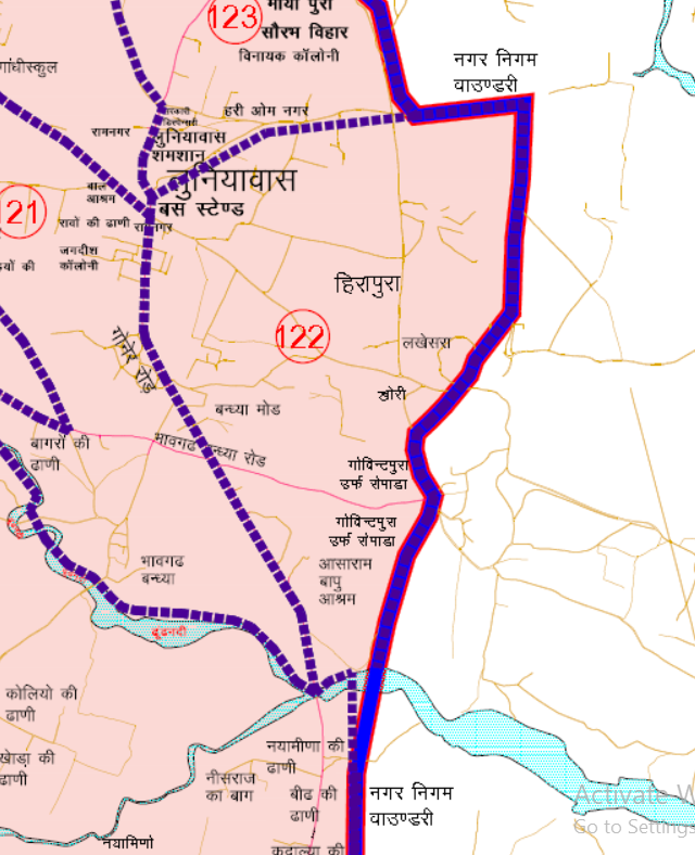
लूणियावास बस स्टैण्ड से प्रारम्भ होकर उत्तर की ओर चलकर दायी ओर के हिस्से को लेते हुये लूणियावास श्मसान के पश्चिम दक्षिण कॉर्नर तक। शमसान के दक्षिण पश्चिम कोर्नर से उत्तर-पूर्व दिशा की ओर चलते हुये दाहिनी तरफ का क्षेत्र लेते हुये नगर निगम की बाउन्ड्री तक। यहाँ से दक्षिणी दिशा में नगर निगम सीमा के सहारे सहारे चलते हुये हीरापुरा, लखेसरा, खोरी, रोपाडा/गोविन्दपुरा के राजस्व ग्रामों को सम्मिलित करते हुये गोनेर रोड नाले तक। यहाँ से पश्चिम की ओर नाले के सहारे सहारे चलते हुए दांये ओर के हिस्से को शामिल करते हुए गोनेर रोड़ तक। यहाँ से उत्तर-पश्चिम दिशा में गोनेर रोड मुख्य सडक पर चलते हुये दाहिने ओर की कॉलोनियां को शामिल करते हुये लूणियावास बस स्टैण्ड तक का समस्त भाग।
JMC Greater Ward 122
Population : 12615
Area: 316 Hectare
Starting from Luniyavas Bus Stand, moving towards the north direction, encompassing the area on the right side, up to the southwest corner of Luniyavas cremation ground. From the southwest corner of the cremation ground, moving towards the northeast direction, including the area on the right side, up to the boundary of the municipal corporation. From here, moving towards the south direction along the boundary of the municipal corporation, including revenue villages of Heerapura, Lakhsera, Khori, and Ropada/Govindpura, up to the canal on Goner Road. From here, moving towards the west direction along the canal, including the area on the right side, up to Goner Road. From here, moving towards the northwest direction along the main road of Goner Road, including colonies on the right side, up to Luniyavas Bus Stand, encompassing the entire stretch.
Google location Map
21 Wards in Bagru Legislative Assembly Constituency
बगरु विधानसभा क्षेत्र में 21 वार्ड
Ward No. 104 | Ward No. 105 | Ward No. 106 | Ward No. 107 | Ward No. 108 | Ward No. 109 | Ward No. 110 | Ward No. 111 | Ward No. 112 | Ward No. 113 | Ward No. 114 | Ward No. 115 | Ward No. 116 | Ward No. 117 | Ward No. 118 | Ward No. 119 | Ward No. 120 | Ward No. 121 | Ward No. 122 | Ward No. 123 | Ward No. 124
Download Map
Register as FD Architects and Planners forum member and login to download map pdf use only for Educational Purposes.
NNJ Greater : Demarcation of Ward in Nagar Nigam Jaipur Greater Map .pdf
NNJ Heritage : Demarcation of Ward in Nagar Nigam Jaipur Heritage Map.pdf
Home page : Demarcation of Ward in Nagar Nigam Jaipur
JDA Jaipur Zone
Zone 1 | Zone 2 | Zone 3 | Zone 4 | Zone 5 | Zone 6 | Zone 7 | Zone 8 | Zone 9 | Zone 10 | Zone 11 | Zone 12 | Zone 13 | Zone 14 | PRN-N1 | PRN-N2 | PRN-S1 | PRN-S2
Register as FD Architects and Planners forum member and login to download map pdf use only for Educational Purposes.
FD Architect & Planning Community Forum Discussion
Division of Nagar Nigam Jaipur in two parts
Disclaimer
The translation may not be an exact word-to-word translation of Gazette Notification but is an attempt to convey the meaning accurately. Information on this site is purely for education purpose. The materials used and displayed on the Sites, including text, photographs, graphics, illustrations and artwork, video, music and sound, and names, logos, IS Codes, are copyrighted items of respective owner. Front Desk is not responsible and liable for information shared above
Page 2 of 16