Density saturation gradient method can be used as a tool for the analysis of existing land use structure and also for use in forecasting land use structure. The forecast is basically a trend projection of the existing land use and density structure in the region. This Density-Saturation Gradient (DSG) Method was first used in Chicago Area Transportation Study (CATS), since then, many researchers have elaborated on this basic work.
The density saturation gradient method is a technique used in land use transport modeling to simulate the distribution of land use and transportation patterns within a region. It is a method for modeling the interaction between land use and transportation, and is based on the idea that the intensity of land use and transportation activities is related to the density of development in a particular area.
The method works by defining a set of zones within the study area, each with a specific land use and transportation profile. The density of development in each zone is then calculated, and a saturation threshold is determined based on the capacity of the transportation network to handle additional traffic.
Once the saturation threshold is established, the model calculates the level of development that can occur within each zone before the threshold is reached. This information is used to predict future development patterns, and to evaluate the impact of transportation infrastructure improvements on land use.
Three empirical rules are used in this method:
1- The intensity of land use declines as the distance or travel time to the CBD
increases.
2- The ratio of the amount of land in use to the amount of available land decreases as distance from the CBD increases.
3- The proportion of land devoted to each type of land use in an area remains stable.
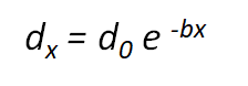
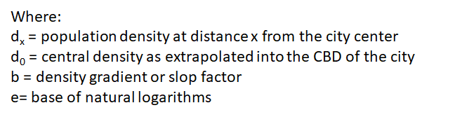
Clark derived the basic equation for expressing this density-distance relationship.
The basic equation:
The density saturation gradient method is a powerful tool for planners and policymakers, as it allows them to simulate different development scenarios and evaluate the potential impact of various policy interventions. By understanding the relationship between land use and transportation, planners can make more informed decisions about where to invest in infrastructure, and how to encourage sustainable development patterns that support economic growth and environmental sustainability.
Other Land use transport model can be
Land use and Transport Planning home page
Download Study Notes PDF
Land use and Transport Planning.pdf
Register as member and login to download attachment use this only for Educational Purpose
FD Planning Community Forum Discussion
- Land Use Transport Integration and Density of Urban Growth Toolkit
- Integration of Land Use and Transport Planning
- Introduction – Modelling Transport – Ortuzar Willumsen
- Mathematical Prerequisites from Modelling Transport
- data and space from Modelling Transport
- Trip Generation Modelling from Modelling Transport
- Modal split and direct demand models from Modelling Transport
- Discrete choice models from Modelling Transport
Disclaimer
Information on this site is purely for education purpose. The materials used and displayed on the Sites, including text, photographs, graphics, illustrations and artwork, video, music and sound, and names, logos, IS Codes, are copyrighted items of respective owners. Front Desk is not responsible and liable for information shared above.
April 20, 2023 at 10:23 am
[…] Density saturation gradient method (DSG) : […]
April 20, 2023 at 10:30 am
[…] Density saturation gradient method (DSG) : […]
April 28, 2023 at 9:33 am
[…] Density saturation gradient method (DSG) : […]
5 Comments
[…] 1.Density saturation gradient method (DSG) : […]
[…] Density saturation gradient method (DSG) : […]