Hansen Accessibility Model (1959) is based upon concept that the more accessible an area is to various activities and the more vacant land area has greater growth potential. This accessibility of an area is an index representing the closeness of area to all other activity in the region .
The Hansen Accessibility Model (HAM) is a land use transportation modeling technique used to measure the accessibility of urban areas to various transportation modes. The model was developed by Steven Hansen in 1959 and has since been modified and expanded upon by other researchers.
The model uses a gravity-based approach to measure the accessibility of different zones within an urban area. The basic premise of the model is that the attractiveness of a location is related to the size of the population or employment base and the distance between that location and other destinations in the region.
HAM calculates the accessibility of each zone by considering the distance to other zones and the population or employment base of each zone. The model then generates a series of accessibility values that reflect the ease with which people can reach different parts of the city using different transportation modes.
The Hansen Accessibility Model has been used in a wide range of applications, including transportation planning, land use planning, and urban design. It has been particularly useful in evaluating the impact of transportation improvements on accessibility and in identifying areas where transportation investments could be most effective.
It is designed to predict the location of population based on the premise that employment is the predominant factor in determining location. He suggested the use of an accessibility index, Aij
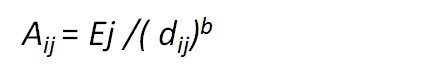
Where
Aij = accessibility index of zone i with respect to zone j
Ej= total employments
dij= distance between i and j
b= an exponent
One of the strengths of the Hansen Accessibility Model is its ability to incorporate different transportation modes, including walking, cycling, public transit, and driving. This makes it a valuable tool for evaluating the impact of multimodal transportation systems on urban accessibility.
Other types of land use transport model are
Land use and Transport Planning home page
Download Study Notes PDF
Land use and Transport Planning.pdf
Register as member and login to download attachment use this only for Educational Purpose
FD Planning Community Forum Discussion
- Land Use Transport Integration and Density of Urban Growth Toolkit
- Integration of Land Use and Transport Planning
- Introduction – Modelling Transport – Ortuzar Willumsen
- Mathematical Prerequisites from Modelling Transport
- data and space from Modelling Transport
- Trip Generation Modelling from Modelling Transport
- Modal split and direct demand models from Modelling Transport
- Discrete choice models from Modelling Transport
Disclaimer
Information on this site is purely for education purpose. The materials used and displayed on the Sites, including text, photographs, graphics, illustrations and artwork, video, music and sound, and names, logos, IS Codes, are copyrighted items of respective owners. Front Desk is not responsible and liable for information shared above.
April 20, 2023 at 10:30 am
[…] Hansen’s accessibility model […]
May 10, 2023 at 7:29 pm
[…] Hansen’s accessibility model (HAM) […]
4 Comments
[…] 2.Hansen’s accessibility model […]
[…] Hansen’s accessibility model […]