Measurement and quantification of Land Use-Transport system
December 25, 2020
Four major categories of variables are measuring the land use system transportation :
Land Use-Transport Model
Four major categories of variables are measuring the transportation / land use system:
Administrative Divisions. Most data is gathered along a spatial framework, which corresponds to administrative divisions. Since the space over which the transportation land use modeling process is undertaken is administered iii one way or another (is it possible to find any portion of space that is not claimed to be administered by a form of institution?). this political attribute is of significant consequence.
Administrative divisions, such as census tracts, neighborhoods, or zoning districts, can provide a useful way of organizing and analyzing data on land use and transportation patterns at a local level. Some common administrative divisions used for this purpose include:
- Census tracts: These are small, relatively homogeneous geographic areas used by the United States Census Bureau to collect and tabulate demographic and socioeconomic data. Census tracts are often used as a unit of analysis for measuring the transportation/land use system, as they can provide detailed information on population, housing, and employment characteristics within a specific area.
- Neighborhoods: These are informal geographic areas defined by community residents, organizations, or local governments. Neighborhoods are often used as a unit of analysis for measuring the transportation/land use system, as they can provide insights into local travel patterns, access to amenities, and community preferences for different transportation modes.
- Zoning districts: These are geographic areas designated by local governments to regulate land use and development. Zoning districts are often used as a unit of analysis for measuring the transportation/land use system, as they can provide information on the distribution of different land uses, such as residential, commercial, and industrial, and their proximity to transportation infrastructure.
- Transit service areas: These are geographic areas defined by the service boundaries of public transit agencies, such as bus or rail systems. Transit service areas are often used as a unit of analysis for measuring the transportation/land use system, as they can provide information on transit accessibility and ridership patterns within a specific area.
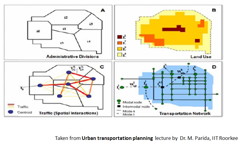
The data collection process inherits the established zoning. such as census districts. counties. Or municipalities, to name a few. In some cases. administrative divisions are politically convenient and structured. but may undermine the validity or relevance of transportation / land use modeling. On the above figure. section A represents a city divided in six administrative divisions (i1 to i6). in which data is acquired and maintained by governmental agencies. It is possible for the modeling process to redefine the divisions of space. but costs are also significantly increased, because the data gathering process would have to be started from scratch.
Land Use. This type of information is commonly maintained as zoning maps, where the formal or functional (preferably) characteristics of the territory are defined. Although this data is mostly qualitative, it is of high relevance since it links spatial information. such as administrative division-related information. to a tangible geographic reality. In section B. the city is characterized by four types of land use (L1 to L4).
If we assume that land use type L1 is commercial. it is logical to conclude that any commercially related data concerning administrative division i4 involves a very
Traffic. This type of information pertains to maintain, validate and update a spatial interaction matrix. Commonly. the centroid of an origin—destination matrix, is an abstraction of an administrative division, as centroid T6 is an abstraction of administrative division i6 (section C). It is that all traffic coming from or going to i6 is generated or attracted by centroid T6. Traffic between centroids is also a component of this matrix, where T32 would represent traffic between zone i3 and i2and T32 would present the opposite. It is also possible to use an index k identifying a mode, if the transportation system is multimodal. which is almost always the case.
Transportation Network. This type of information is related to the characteristics and structure of transportation infrastructures. The network is commonly represented as a geometric construct composed of nodes and segments. In the case of a multimodal network. such as the one portrayed on section D. there are two types of segments and intermodal nodes (Ik1) are possible.
The mediating factor in determining changes in the location of activities and the demand for travel is accessibility, which measures the situation of a location relative to other activities or opportunities (work, shopping, etc.) distributed in space. Changes in relative accessibility are measured indirectly when researchers attempt to identify
the influence of new infrastructure, such as a highway link or transit station, on local land markets.
The purpose of land use transport models is to assess the policy impacts in terms of the implications of the future growth patterns on both land use and travel related issues .For this purpose, several researchers have developed various models with different theoretical backgrounds and data requirements
Types of land use transport model are
- Density saturation gradient method (DSG) :
- Hansen’s accessibility model
- Intervening opportunity model
- Garin Lowry model
Land use and Transport Planning home page
Download Study Notes PDF
Land use and Transport Planning.pdf
Register as member and login to download attachment use this only for Educational Purpose
FD Planning Community Forum Discussion
- Land Use Transport Integration and Density of Urban Growth Toolkit
- Integration of Land Use and Transport Planning
- Introduction – Modelling Transport – Ortuzar Willumsen
- Mathematical Prerequisites from Modelling Transport
- data and space from Modelling Transport
- Trip Generation Modelling from Modelling Transport
- Modal split and direct demand models from Modelling Transport
- Discrete choice models from Modelling Transport
Disclaimer
Information on this site is purely for education purpose. The materials used and displayed on the Sites, including text, photographs, graphics, illustrations and artwork, video, music and sound, and names, logos, IS Codes, are copyrighted items of respective owners. Front Desk is not responsible and liable for information shared above.
1 Comment
[…] Measurement and quantification of Land Use-Transport system […]