A land use – transportation system can be divided in three component models:
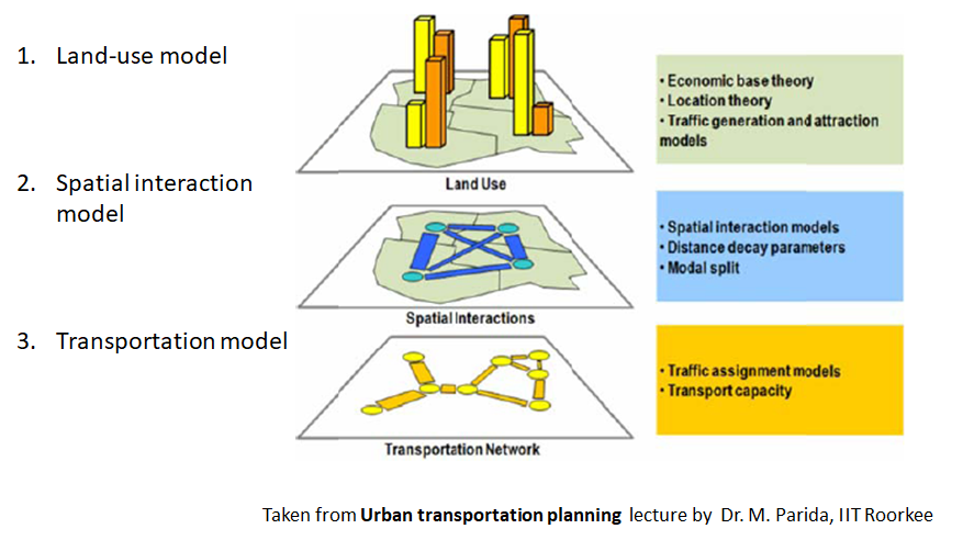
1 Land use models
Land use models are generally concerned about the spatial structure of macro and micro—economic components. which are often correlated with transportation requirements. For instance, by using a set of economic activity variables, such as population and level of consumption it becomes possible to calculate the generation and attraction of passengers and freight flows.
Land use models are mathematical representations of the interactions between various land uses and their associated transportation systems. A land use-transportation system model seeks to understand and predict the relationship between land use patterns and transportation systems, and how they impact each other.
The main components of a land use-transportation system model typically include:
- Land Use Patterns: The model incorporates data on the spatial distribution of different land uses within a study area, such as residential, commercial, and industrial land uses.
- Travel Demand: The model estimates the demand for travel in the study area, based on factors such as population, employment, and trip purposes. This information is then used to predict the number and types of trips that will be made within the study area.
- Transportation Network: The model includes data on the transportation infrastructure within the study area, such as roads, highways, public transit, and pedestrian/bicycle facilities.
- Travel Behavior: The model takes into account the travel behavior of individuals, including mode choice (car, public transit, bicycle, walking, etc.), trip frequency, and trip purpose.
- Land Use-Transportation Interactions: The model predicts the impact of land use patterns on transportation systems, and vice versa. For example, it can predict how changes in land use patterns (such as the construction of a new shopping mall) will affect transportation patterns (such as increased traffic congestion).
- Scenarios Analysis: The model can be used to explore different scenarios or options for future land use and transportation planning, allowing decision-makers to evaluate the likely impacts of different policy choices and make informed decisions.
Land use-transportation system models can help planners and policymakers make more informed decisions about transportation and land use planning. By predicting the impacts of different land use and transportation scenarios, they can help identify strategies that promote sustainable and efficient land use patterns and transportation systems.
2. Spatial interactions models
2. Spatial interactions models are mostly concerned about the spatial distribution of movements, a function of land use (demand) and transportation infrastructure (supply). They produce flow estimates between spatial entities. symbolized by origin destination pairs. which can be disaggregated by nature. mode and time of the clay.
Spatial interaction models are mathematical models that are used to analyze and predict the flow of people, goods, or information between different locations. When combined with land use and transportation data, spatial interaction models can help to better understand the relationship between land use patterns and transportation systems.
In the context of land use-transportation systems, spatial interaction models can be used to:
- Analyze the flow of people or goods between different locations within a study area, and identify the key factors that influence those flows.
- Predict the impact of changes in land use patterns on the flow of people or goods within the study area, and vice versa.
- Evaluate the efficiency of transportation systems in moving people or goods between different locations, and identify areas where improvements could be made.
- Assess the impact of transportation policies or interventions on land use patterns and the flow of people or goods within the study area.
There are several types of spatial interaction models that can be used in the context of land use-transportation systems, including gravity models, radiation models, and spatial interaction network models.
Gravity models are one of the most commonly used spatial interaction models in land use-transportation planning. They are based on the idea that the flow of people or goods between two locations is proportional to the product of the population or employment at each location, and inversely proportional to the distance between them. Gravity models can be used to predict the flow of people or goods between different locations within a study area, and to identify the key factors that influence those flows.
Radiation models are another type of spatial interaction model that can be used in the context of land use-transportation systems. They are based on the idea that the flow of people or goods from one location to another is influenced not only by the distance between the locations, but also by the attractiveness of the destination location and the availability of alternative routes. Radiation models can be used to predict the flow of people or goods between different locations within a study area, and to evaluate the efficiency of different transportation systems in moving people or goods between those locations.
Spatial interaction network models are a more complex type of spatial interaction model that can be used to analyze the flow of people or goods within a network of locations, such as a transportation system. They take into account the spatial relationships between different locations and the characteristics of the transportation system (such as mode of transportation, travel time, and capacity), and can be used to predict the flow of people or goods between different locations within the network.
3.Transportation network models
Transportation network models are trying to evaluate how movements are allocated over a transportation network, often of several modes. notably private and public transportation. They provide traffic estimates for any given segment of a transportation network.
To provide a comprehensive modeling framework, all these models must share information to form an integrated transportation / land use model. For instance, a land use model can calculate traffic generation and attraction. which can be inputted in a spatial interaction model. The origin—destination matrix provided by a spatial interaction model can be inputted in a traffic assignment model. resulting in simulated flows on the transportation network.
Transportation network models are mathematical models that are used to simulate the flow of traffic on transportation networks, such as roads, highways, and public transit systems. These models are often used in transportation planning and engineering to evaluate the performance of existing transportation systems, and to design and evaluate new transportation projects.
Transportation network models can be used to:
- Evaluate the performance of transportation systems in terms of travel time, delay, and congestion.
- Identify the causes of congestion and delays, such as bottlenecks or accidents, and evaluate potential solutions.
- Design and evaluate transportation projects, such as new highways or public transit lines, to determine their potential impact on traffic flow and travel time.
- Plan and manage transportation systems to ensure efficient and effective use of resources.
There are several types of transportation network models, including static models, dynamic models, and hybrid models.
Static models are the simplest type of transportation network model. They are based on the assumption that traffic flow on the network is constant and does not change over time. Static models can be used to evaluate the performance of transportation systems under normal conditions, but they cannot account for changes in traffic flow due to incidents or other disruptions.
Dynamic models, on the other hand, take into account changes in traffic flow over time. They can simulate the impact of incidents or other disruptions on traffic flow, and can be used to evaluate the effectiveness of different strategies for managing traffic flow under these conditions.
Hybrid models combine elements of both static and dynamic models, and are often used to simulate complex transportation systems that include both highways and public transit. They can simulate the impact of changes in traffic flow on public transit, and can be used to evaluate the effectiveness of strategies for managing both highway and public transit systems.
Transportation network models are an important tool for transportation planners and engineers, and are used extensively in the design and management of transportation systems around the world.
Measurement and quantification of Land Use-Transport system
Land use and Transport Planning home page
Download Study Notes PDF
Land use and Transport Planning.pdf
Register as member and login to download attachment use this only for Educational Purpose
FD Planning Community Forum Discussion
- Land Use Transport Integration and Density of Urban Growth Toolkit
- Integration of Land Use and Transport Planning
- Introduction – Modelling Transport – Ortuzar Willumsen
- Mathematical Prerequisites from Modelling Transport
- data and space from Modelling Transport
- Trip Generation Modelling from Modelling Transport
- Modal split and direct demand models from Modelling Transport
- Discrete choice models from Modelling Transport
Disclaimer
Information on this site is purely for education purpose. The materials used and displayed on the Sites, including text, photographs, graphics, illustrations and artwork, video, music and sound, and names, logos, IS Codes, are copyrighted items of respective owners. Front Desk is not responsible and liable for information shared above.
2 Comments
[…] Component of Land Use-Transport Model […]
[…] Component of Land Use-Transport Model […]