Approach for TOD Implementation National TOD policy
December 27, 2020
India’s National Transit Oriented Development (TOD) Policy provides a comprehensive approach for implementing TOD in Indian cities.
Influence Zone
The area in the immediate vicinity of the transit station, i.e. within a walking distance, having high density compact development with mixed land use to support all basic needs of the residents is called the influence zone of a transit station/ corridor
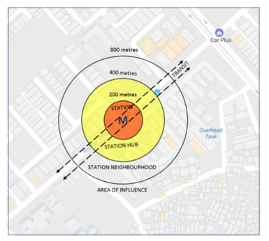
The Influence Zone is the immediate vicinity of a transit station, typically within a radius of 200-400-800 meters or a 10-15 minute walk. This area is characterized by high accessibility to transit services, and therefore has the potential to attract a significant amount of development and activity. The Influence Zone is a critical component of Transit-Oriented Development (TOD) planning, as it offers an opportunity to create compact, walkable, and mixed-use developments that leverage the benefits of transit access.
Within the Influence Zone, a range of land uses can be accommodated, including residential, commercial, office, and institutional uses. The mix of land uses should be carefully planned to ensure that there is a balance between the demand for housing, employment, and services. By encouraging a mix of land uses, the Influence Zone can help reduce travel demand and promote non-motorized modes of transport, such as walking and cycling.
In addition to land use planning, the Influence Zone should also prioritize the design of public spaces and streets. Public spaces such as plazas, parks, and open spaces can serve as focal points for community activity and provide opportunities for social interaction and recreation. Streets should be designed to prioritize pedestrian and bicycle traffic, with wide sidewalks, dedicated cycle tracks, and low-speed traffic.
High Density Compact Development
TOD promotes densification in the influence area by providing higher Floor Area Ratio (FAR)/ Floor Space Index (FSI) and higher population & job density as compared to the area around and beyond the influence areas. To ensure sustainable development, the minimum FAR should be 300 – 500%, and can be higher, depending on the city size.
High-density compact development is a key component of Transit-Oriented Development (TOD), which aims to create more sustainable and livable urban environments by promoting compact, mixed-use development around transit stations. High-density development refers to buildings with a greater number of units per unit of land area, while compact development refers to development with a greater mix of land uses, such as residential, commercial, and institutional uses.
In TOD, high-density compact development is important because it promotes more efficient land use, reduces travel distances, and encourages non-motorized modes of transport such as walking and cycling. High-density development also creates more vibrant and diverse urban environments by bringing people and activities closer together, and can help to reduce the carbon footprint of urban areas by reducing the amount of energy used for transportation.
However, high-density development must be carefully planned and designed to ensure that it is both livable and sustainable. Some of the key considerations for high-density development in TOD include:
- Adequate infrastructure: High-density development requires sufficient infrastructure to support the increased population density, including water, sewer, and transportation infrastructure.
- Affordable housing: High-density development should include provisions for affordable housing to ensure that the benefits of transit access are accessible to all socio-economic groups.
- Public space: High-density development should prioritize the design of public spaces, such as parks and plazas, to provide opportunities for social interaction and recreation.
- Pedestrian and bicycle infrastructure: High-density development should prioritize the design of pedestrian and bicycle infrastructure, such as wide sidewalks, dedicated cycle tracks, and low-speed traffic, to promote non-motorized modes of transport.
- Design guidelines: High-density development should be guided by design guidelines that promote livable and sustainable urban environments, including building setbacks, building heights, and open space requirements.
Mixed Use Development
Mixed land use should be stipulated for development/ redevelopment in the TOD zone as it would reduce the need for travel by providing most of the activities such as shopping, entertainment and public amenities such as schools, parks, playgrounds, hospitals etc. within the walking distance of the residents.
Mixed-use development in a Transit-Oriented Development (TOD) zone refers to the integration of various land uses, such as residential, commercial, and office spaces within close proximity to public transportation hubs, such as train stations or bus stops. The aim is to create a vibrant and walkable community that encourages residents to use public transportation, reducing reliance on private vehicles and decreasing carbon emissions.
A mixed-use development in a TOD zone can have several benefits, including:
- Improved access to public transportation: By locating a mix of uses close to public transportation hubs, people can more easily access public transportation, reducing the need for private vehicles and creating a more sustainable community.
- Increased walkability: With a mix of uses in close proximity, residents can more easily walk to destinations such as shops, restaurants, and parks, creating a more pedestrian-friendly environment.
- Economic benefits: Mixed-use developments can create new job opportunities and increase the tax base of a community, while also providing convenient amenities for residents.
- Social benefits: Mixed-use developments can create a sense of community and provide a variety of amenities for residents, such as parks, community centers, and public spaces.
- Environmental benefits: By reducing the need for private vehicles and creating more sustainable communities, mixed-use developments can help reduce carbon emissions and mitigate the effects of climate change.
Mandatory and Inclusive Housing
Mandatory and inclusive housing refer to policies and regulations that require developers to include affordable housing units in their residential developments. The aim is to ensure that people of different income levels can live in the same neighborhood, promoting diversity and reducing income segregation.
The cities should fix a minimum percentage (30% or higher) of allowed FAR for affordable housing (for example up to 60 sq.mt. area) in all development/redevelopment in the influence zones.
Housing in the influence zone should have a mix of all economic groups/ sections. The development control regulation should stipulate housing for Economically Weaker Sections (EWS) as well as LIG/MIG.
In the context of influence zones, which are areas surrounding public transportation hubs, mandatory and inclusive housing policies can help ensure that people who rely on public transportation have access to affordable housing options. These policies can be implemented through a variety of mechanisms, such as:
- Inclusionary zoning: This policy requires developers to set aside a percentage of new residential units for affordable housing, typically by offering a certain number of units at below-market prices or by paying a fee to support affordable housing elsewhere in the community.
- Density bonuses: This policy allows developers to build additional units in exchange for including a certain percentage of affordable units in their developments.
- Housing trust funds: This policy collects funds from developers to support the creation of affordable housing in the community.
- Tax incentives: This policy provides tax breaks for developers who include affordable housing units in their developments.
Multimodal Integration
The influence area should have high quality integrated multimodal transport system for the optimum use of the facilities by the residents/users. The system should have seamless physical connectivity, information integration and fare integration across modes so that the first and last mile connectivity does not become a bottleneck in the use of public transit systems by the citizens.
Focus on pedestrians, cyclists and NMT users
The streets should be designed for users of all age groups and for all types of commuters including pedestrians, bicyclists, motorists and transit riders. They should be safe and accessible by all.
•Universal Accessibility: All streets should be designed to meet or exceed the minimum standards stipulated for barrier free environment by Government of India1 to ensure universal accessibility for people with reduced mobility including visually and hearing impaired persons
Traffic Calming: To promote a safe and secure environment for pedestrian and NMT users, necessary measures should be taken to reduce speed as well as volume of motorized traffic in the influence zone.
Street Oriented Buildings and Vibrant Public Spaces
Retail and other ‘active uses’ should be supported on the ground floor along the main streets, key intersections, stations and parking garages to ensure high quality pedestrian environments.
•Street Vendors: TOD aims at inclusive development wherein all users of the system are benefited. The street vendors are the eyes of the streets; hence the designated spaces should be created for them while designing the streets.
•Preserve Open Spaces: All open areas such as amenity spaces, green spaces, playgrounds, parks and natural areas should be preserved as part of TOD.
•Safety and Security: To ensure a safe and secure environment for pedestrian and NMT users, especially women and children, the influence zone should be designed to maximize natural surveillance.
Managed Parking
To discourage the use of private vehicles and to manage parking in TOD, it is essential that the supply of the parking is reduced and made expensive within the influence zone.
Land use and Transport Planning home page
Download Study Notes PDF
Land use and Transport Planning.pdf
Register as member and login to download attachment use this only for Educational Purpose
FD Planning Community Forum Discussion
- Land Use Transport Integration and Density of Urban Growth Toolkit
- Integration of Land Use and Transport Planning
- Introduction – Modelling Transport – Ortuzar Willumsen
- Mathematical Prerequisites from Modelling Transport
- data and space from Modelling Transport
- Trip Generation Modelling from Modelling Transport
- Modal split and direct demand models from Modelling Transport
- Discrete choice models from Modelling Transport
Disclaimer
Information on this site is purely for education purpose. The materials used and displayed on the Sites, including text, photographs, graphics, illustrations and artwork, video, music and sound, and names, logos, IS Codes, are copyrighted items of respective owners. Front Desk is not responsible and liable for information shared above
1 Comment
[…] Approach for TOD Implementation National TOD policy […]