Case cities of land use –transport integration : Ahmedabad
December 25, 2020
Ahmedabad, located in the state of Gujarat in India, is often cited as a case study for successful land use-transport integration. The city has undergone significant transformation over the past few decades, with a focus on promoting sustainable and equitable growth.
Urban Structure
Ahmedabad has a poly-centric structure. It has retained a ‘relatively compact structure’ with mixed use development owing to effective town planning practices, although it has shown ‘gradual tendencies of dispersal’ especially in the peripheral areas of the city
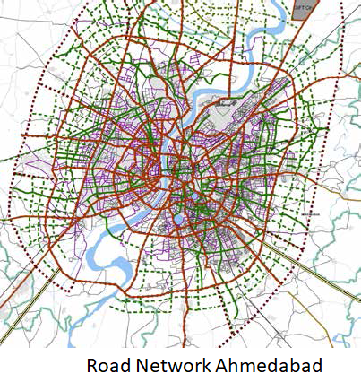
Network and streets
Ahmedabad has a balanced ring-radial network of streets, with 5 ring roads and 20 radials with a road length of 2400 km . The city has grown on both eastern and western parts of the river Sabarmati which are connected by 7 bridges. The road network of the city has contributed in the high density development and compactness of the city. The 20 well defined radials include 12 in the west and 8 in the east of the city and act as important axes of development. As the need to connect these radials arose, the 5 ring or orbital roads were planned in Ahmedabad. These roads have experienced fast-paced development in the last decade.
Strategic Alignment and TOD
A multi-modal transport network has been planned for the city of Ahmedabad as recognition of the fact that no single mode can cater to the rising travel demands of the population. Currently, Ahmedabad is serviced by road-based public transit services; the regular bus service is provided by the Ahmedabad Municipal Transport Services (AMTS) and the Bus Rapid Transit System (BRTS) by Ahmedabad Janmarg Limited.
AMTS covers almost 97% of the developed area within the AMC limits with 212 routes covering 550 km of road network . The network of AMTS has been so aligned that 80% of the routes pass through areas with low and middle income households.
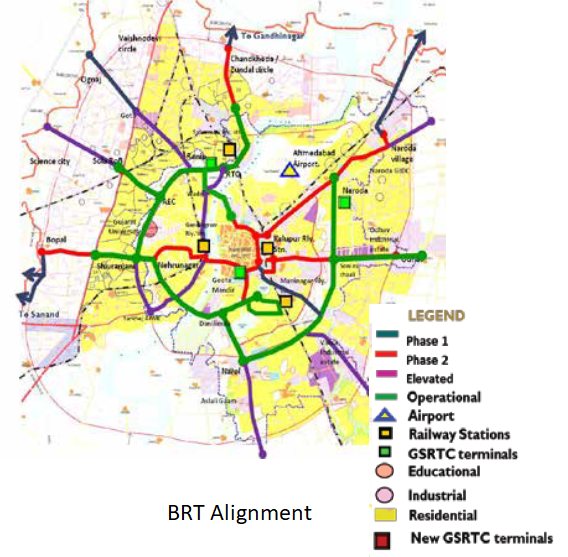
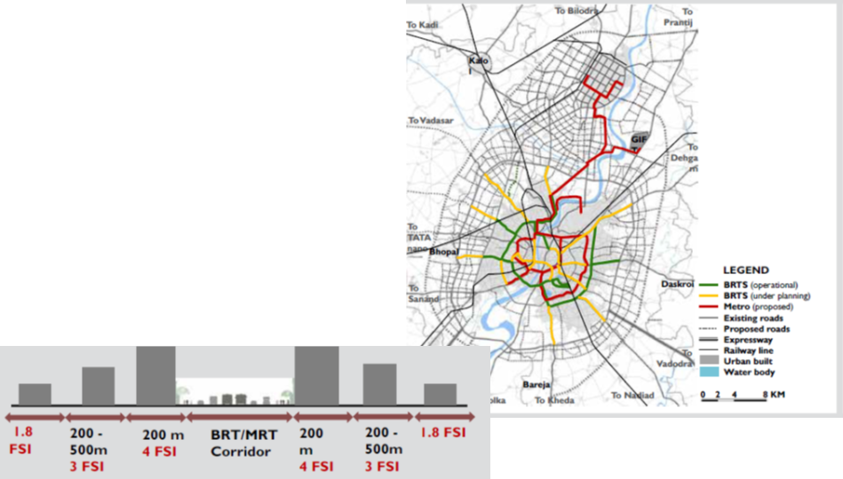
Multimodal Transit System with TOD (Transit Oriented Development)
As per the Integrated Mobility Plan Ahmedabad 2012 increase in the FSI is also proposed along the BRT and the MRT network.
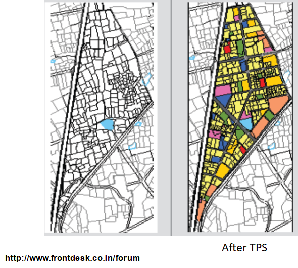
DP-TP Scheme as Legal Instrument of Comprehensive Planning
Rapid economic development and urbanization have led to the mandate of the Gujarat Town Planning and Urban Development Act (GTPUDA 1976), according to which planning of the Ahmedabad city is a two-step process: 1)the formulation of a Development Plan (DP) for the urban development area on the periphery of the municipal limits, 2)the preparation of Town Planning Schemes (TPS) to implement the proposals of the DP.
The DP-TP Scheme process is implemented through The Development Control Regulations (DCR) and the building bye-laws control the zoning in the city. Land-use zoning in the city enables commercial activities on all roads of 18 m or more width, ensuring mixed-use development and creating Ahmedabad into a “Shopping street city”.
BRT SYSTEM
One of the key elements of Ahmedabad’s success has been the development of a high-quality bus rapid transit (BRT) system, which has been integrated with land use planning to promote compact and mixed-use development patterns. The BRT system, known as Janmarg, includes dedicated bus lanes, off-board fare collection, and other features that prioritize the movement of public transit vehicles over private vehicles.
In addition to the BRT system, Ahmedabad has also implemented a range of other transportation initiatives that promote sustainable and equitable growth. These include:
- Pedestrianization of streets: The city has implemented pedestrianization of streets in several areas, creating safe and attractive spaces for walking and cycling.
- Bike-sharing program: Ahmedabad has implemented a bike-sharing program, providing residents with access to low-cost bicycles for short trips.
- Mixed-use development: The city has implemented policies to promote mixed-use development, encouraging the construction of residential and commercial buildings in close proximity to each other and to transportation options.
- Smart parking: Ahmedabad has implemented a smart parking system, which uses technology to optimize the use of parking spaces and reduce traffic congestion.
- Transit-oriented development: The city has implemented policies to encourage development near transit stations, promoting more sustainable and efficient use of transportation infrastructure.
TOWN PLANNING SCHEME – A LAND READJUSTMENT TOOL
•Reconstitution of land holdings
•Appropriation of land for public uses without acquisition (up to 50%)
•Local level road network (utpto20%)
•Local level social and physical infrastructure (5%)
•Land Bank for Urban Poor (up to 10%)
•Land appropriation compensation adjusted against land value increments due to infra. provision
•Land Bank for Financing of infrastructure (15%)
Town Planning Scheme regulations for implementing proposals.
Ahmedabad’s success in promoting land use-transport integration demonstrates the benefits of a coordinated approach to transportation planning. By prioritizing sustainable and equitable growth and integrating transportation infrastructure with land use planning, the city has created a more livable and vibrant urban environment for its residents.
Tools for Land use –Transport Integration
- Density
- Land use Mix
- Strategic Network
- TOD and DOT
Land use and Transport Planning home page
Download Study Notes PDF
Land use and Transport Planning.pdf
Register as member and login to download attachment use this only for Educational Purpose
FD Planning Community Forum Discussion
- Land Use Transport Integration and Density of Urban Growth Toolkit
- Integration of Land Use and Transport Planning
- Introduction – Modelling Transport – Ortuzar Willumsen
- Mathematical Prerequisites from Modelling Transport
- data and space from Modelling Transport
- Trip Generation Modelling from Modelling Transport
- Modal split and direct demand models from Modelling Transport
- Discrete choice models from Modelling Transport
Disclaimer
Information on this site is purely for education purpose. The materials used and displayed on the Sites, including text, photographs, graphics, illustrations and artwork, video, music and sound, and names, logos, IS Codes, are copyrighted items of respective owners. Front Desk is not responsible and liable for information shared above.
2 Comments
[…] Case cities of land use –transport integration : Ahmedabad […]
[…] Case cities of land use –transport integration : Ahmedabad […]