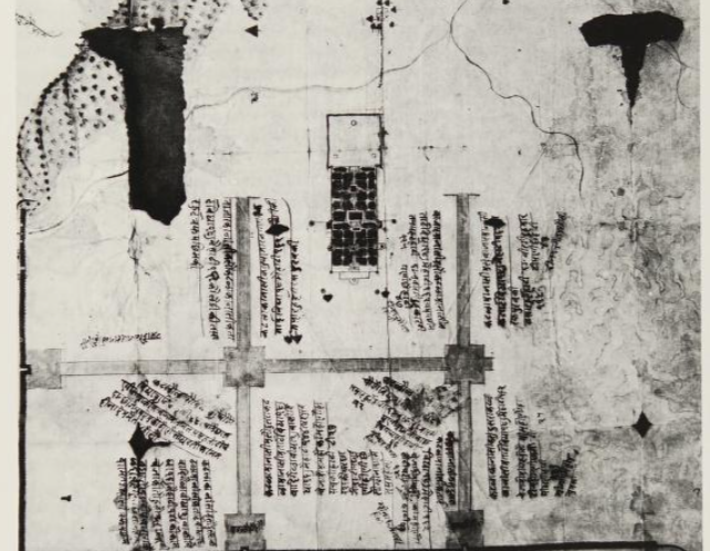

Jaipur – UNESCO World Heritage City
At the heart of Jaipur’s identity lies its chowkri system—the wards defined by the city’s broad, intersecting streets. These divisions were not arbitrary; they were part of the city’s original mandala-inspired plan and each chowkri carried a functional, symbolic, or cultural role.
The names of these chowkris, though sometimes later adaptations, still reveal traces of their original character:
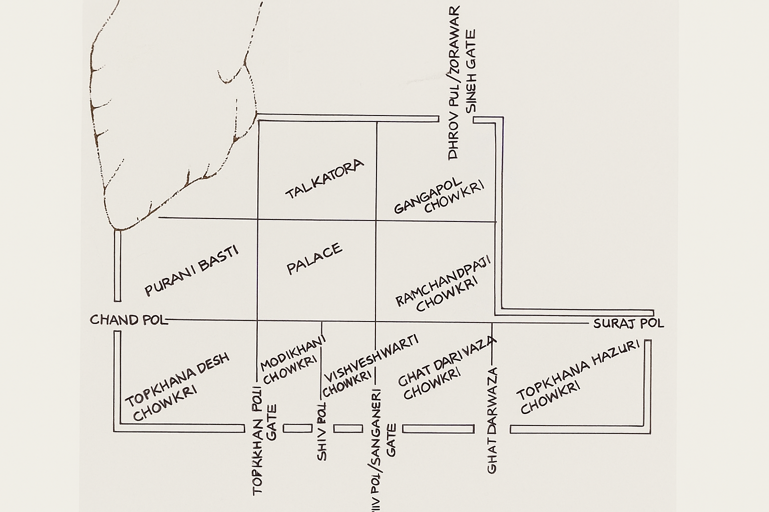
- Topkhana Desh (South-West) and Topkhana Hazuri (East Extension) – Both names translate to “arms store,” suggesting that these quarters were conceived as corner bastions of the fortified city.
- Ghat Darwaza (South-East) – Named after the gate on the city’s southern wall, it linked Jaipur with the routes leading eastward through the hills.
The Central Axis and Chaura Rasta
At the city’s centre, in front of the City Palace, lies a division into two wards:
- Modi (West)
- Vishveshvarji (East) – named after the Vishveshvarji temple, built in the 19th century.
Between them runs Chaura Rasta, one of Jaipur’s great streets, as wide as the city’s other main arteries. This road, aligned with the Tripolia Gate of the palace to the Naya Pol on the southern wall, reinforces the city’s central axis. It also symbolically asserts the centrality of the palace in Jaipur’s geometry and governance.
Some historians once suggested that both Chaura Rasta and Naya Pol were 19th-century additions, given the name “New Gate.” However, 18th-century maps and documents already depict them, proving they were integral to Jai Singh’s original plan. The confusion arose only because Naya Pol was later rebuilt, and several prominent buildings lining Chaura Rasta were constructed in subsequent centuries.
The Central Zone
Jaipur’s central zone is home to three chowkris, arranged west to east:
- Purani Basti – The “old quarter,” possibly the earliest constructed part of the city, its name is a reminder of Jaipur’s beginnings.
- Palace Sarahad – The walled compound of the City Palace, forming the symbolic and political heart of Jaipur.
- Ramchandraji – Named after a 19th-century temple dedicated to Lord Ram.
The Northern Zone
The northern stretch of Jaipur presented unique challenges. The Aravalli hill range to the west and the large Tal Katora tank behind the palace restricted construction. As a result:
- The western ward was never properly developed, being absorbed by the hillside.
- The central northern zone was dominated by Tal Katora.
- To the east lay Gangapol Chowkri, named after a minor gate in the city’s northeast corner.
In its chowkris, Jaipur demonstrates how geometry, defense, ritual alignment, and urban living merged into one harmonious whole. Each ward carries layers of history—from defense zones to temples, from early settlements to royal compounds—making the city not just a planned space, but a living organism.
The Planned Structure of Jaipur’s Walled City
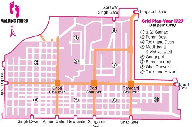
Maharaja Sawai Jai Singh II’s vision of Jaipur was that of a carefully planned capital, drawing from the principles of Shilpa Shastra and Vastu Vidya. The city was laid out on a grid pattern, divided into distinct blocks (chowkris), protected by massive walls with monumental gates, and punctuated by broad public squares (chaupars).
The 9 Chowkris (City Blocks)
Each block had a defined social and functional purpose:
1–2. Chowkri Sarhad – The royal palace block, housing the City Palace, Chandra Mahal (present Maharaja’s residence), Govind Devji Temple, the UNESCO site Jantar Mantar, Hawa Mahal, and palace gardens.
3. Chowkri Purani Basti – Residences of leading courtiers and nobles.
4. Chowkri Topkhana Desh – Mansions of thikanedars, chiefs of different state divisions.
5. Chowkri Modikhana & Vishveshwarji – Merchant havelis and homes of royal officials, some still maintained by their descendants.
6. Chowkri Gangapol – A key quarter linked with artisans and military use.
7. Chowkri Ramchandraji – Noted for temples built by royals and nobles.
8. Chowkri Ghat Darwaza – Mixed settlement of merchants, artists, and workers.
9. Chowkri Topkhana Hazuri – Along with Gangapol, used by the artillery and labour force.
The nine planned Chowkris (blocks) of Jaipur are laid out in a perfect grid, defined by the main north–south and east–west streets of the city. Their areas (based on GIS mapping) are as follows:
| S. No. | Name of Chowkri | Dimensions (mts) | Area (hectare) |
|---|---|---|---|
| 1. | Chowkri Ram Chandra Ji | 720 × 880 | 64.40 |
| 2. | Chowkri Ghat Darwaja | 800 × 800 | 68.10 |
| 3. | Chowkri Topkhana Desh | 800 × 900 | 74.68 |
| 4. | Chowkri Topkhana Hazuri | 800 × 1000 | 84.66 |
| 5. | Chowkri Ganga Pol | 800 × 515 | 54.48 |
| 6. | Chowkri Sarhad (Royal Precincts) | 900 × 1200 | 43.57 |
| 7. | Chowkri Vishveshwar Ji | 800 × 400 | 35.00 |
| 8. | Chowkri Modikhana | 800 × 400 | 35.00 |
| 9. | Chowkri Purani Basti | 800 × 1420 | 113.60 |
| Total Walled City Area | 674.00 |
Total Walled City Area: 674 hectares (≈ 1,665.50 acres)
The 9 Gates of Jaipur
The 3 Chaupars (Public Squares)
At key crossroads, three broad squares served as centers of public life and marketplaces:
- Badi Chaupar (Large Square)
- Choti Chaupar (Small Square)
- Ramganj Chaupar
This structure gave Jaipur its unique balance between royal, commercial, and sacred spaces. The deliberate zoning of chowkris, the protective walls with gateways, and the organizing presence of the chaupars ensured a city that was not just functional and defensible, but also harmonious, symbolic, and inclusive.
Home page : Jaipur – UNESCO World Heritage City
The Chowkris – The Wards of Jaipur | The Mohallas – Life Within the Wards | Jal Mahal and Ishvar Lat Jaipur | Hawa Mahal – The Palace of Winds | Jaipur Heritage Walk | Important Bazar | Chowkri Modikhana | Chowkri Vishveshwarji
Jeypore portfolio of architecture details : Part-1 Coping and Plinths
Plate 1 | Plate 2 | Plate 3 | Plate 4 | Plate 5 | Plate 6 | Plate 7 | Plate 8 | Plate 9 | Plate 10 | Plate 11 | Plate 12 | Plate 13 | Plate 14 | Plate 15 | Plate 16 | Plate 17 | Plate 18 | Plate 19 | Plate 20 | Plate 21 | Plate 22 | Plate 23
Reference: Building Jaipur : the making of an Indian city by Sachdev, Vibhuti
SPECIAL AREA HERITAGE DEVELOPMENT PLAN (WALLED CITY – JAIPUR) 2041
Disclaimer
Information on this site is purely for education purpose. The materials used and displayed on the Sites, including text, photographs, graphics, illustrations and artwork, video, music and sound, and names, logos, IS Codes, are copyrighted items of respective owner. Front Desk is not responsible and liable for information shared above.